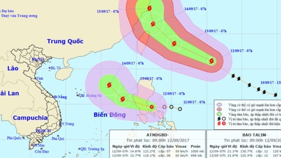
At 7am today, its eye was centered at 14.6 degrees north latitude and 122.2 degrees east longitude of the central region of the Philippines with its strongest wind near the center gusted 50-60 kilometers per hour.
Within next 24 hours, the depression will move the west- northwestwards at 15- 20 kilometers an hour, after that it is predicted to turn into the typhoon.
By 7am tomorrow, the pressure system will be located at 15.7 degrees north latitude and 118.1 degrees east longitude of the southeastwards of the Philippines’s Luzon Island. The powerful wind near the center will blow level 8-10.
Because of an influence of the depression, the eastern territorial water of the mid- East Sea will see level 6-7 wind, even gust up to level 8-10 and sea rough.
The dangerous zone will be at 13 degrees north latitude and 115 degrees east longitude in next 24- 48 hours.
According to the National Hydrology Meteorology Forecast Center, typhoon Talim was located at 21. 1 degrees north latitude and 130.7 degrees east longitude this morning.
Within next 24 hours, the tropical storm will quickly move the west- northwestward at 30 kilometers an hour.
By 7am tomorrow, it will be at 410 kilometers of the east- southeastward of Taiwan Island (China) with its peak wind of 150- 185 kilometers per hour.


)


