As a result, multiple areas are now cooler than previous days, with mountainous regions turning chilly.

The agency reported that the new cold air mass has intensified northeasterly winds, bringing cloudy skies and showers to the capital city of Hanoi and the Red River Delta provinces, from the night of October 22 to the morning of October 23.
Early this morning, numerous residents wore warmer clothing, and morning traffic slowed at city entrances due to slick roads and cold gusts.
Temperatures in downtown Hanoi, such as around Hoan Kiem District, fell to around 19 degrees Celsius at 7 a.m.
")
In the Northern mountainous areas, temperatures dropped significantly, notably 14 degrees Celsius in Lai Chau Province.
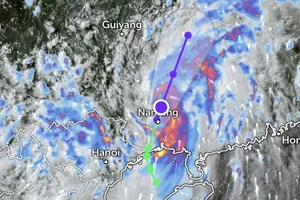
The cold air mass has also begun to affect the Central region as tropical storm No. 12 weakened into a low-pressure area. The storm’s circulation, combined with the cold air, has created a strong wind convergence zone.
Light rain has been observed in Thanh Hoa and Nghe An provinces, with heavier showers developing along the Nghe An coastline. From Ha Tinh to Da Nang, rainfall is forecast to increase on the night of October 23, likely persisting over the next several days.
Meteorologists forecast that on October 24, the cold air mass will maintain its strength before gradually weakening in the following days. From October 25 onward, temperatures in the Northern region are expected to rise slightly, bringing cooler and more comfortable weather after the season’s first cold spell.