This overlap may cause widespread and severe waterlogging across various areas in multiple regions.
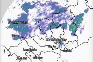
In 2025, the Mekong Delta is anticipated to experience small floods in early October, with potential peak flood levels at Tan Chau monitoring station ranging from 3.2 meters to 3.5 meters, and from 3.0 meters to 3.3 meters at Chau Doc monitoring station, equivalent to approximately alert level 1.
However, water levels may rise unexpectedly due to a combination of seasonal floods, localized rains and high tide levels, potentially resulting in abnormal waterlogging.

In Ca Mau Peninsula, the Cai Lon – Cai Be irrigation system is expected to be affected by upstream water flows, high tides and local rainfall, with maximum water levels at monitoring stations ranging from 0.7 meters to 1.15 meters.
Areas along rivers may be inundated.

Specialized agencies recommend that local authorities should proactively review response plans, reinforce embankments and control water levels in order to minimize damage to agriculture and livelihoods.


)