As forecast, additional two cold fronts are expected to trigger excessive rainfalls and huge risk of flooding in the Northern and Central regions until the end of this month.
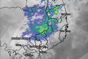
The cold air wave is compressing and pushing a low-pressure trough as this system is overrunning to the Southern region.
Because of an influence of the low- pressure trough, North-Central provinces including Thanh Hoa and Nghe An are expected to suffer small- medium to heavy downpours and thunderstorms from the nightime of October 24.
The cold air mass begins powerfully operating and bringing cooler temperature in the Northern region from this week.
Last week, the Central region braced for a deadly torrential downpour and huge flooding. Accordingly, four people lost their life and five others were injured due to the natural disaster.
Meteorological experts recommended that the Central region should actively deal with new torrential downpour and huge flooding under the impact of the upcoming cold spells.