Building the underground city
")
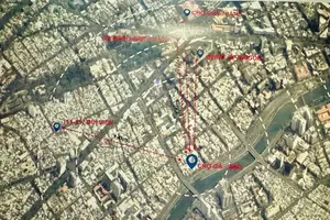
According to the Prime Minister’s Decision No. 1125/QD-TTg to approve the adjusted master plan for Ho Chi Minh City through 2040, with a vision extending to 2060, on June 11, 2025, it has set a framework for the city’s underground spatial planning. The plan encourages the development of urban underground spaces in key growth areas, with particular emphasis on central urban districts and existing urban zones. It aims to integrate underground public transportation systems, parking facilities, and pedestrian tunnels into a comprehensive subterranean network, thereby alleviating surface traffic congestion. Additionally, the plan calls for the construction of underground technical routes along major urban roads and external traffic arteries.
The development of underground urban spaces must comply with safety regulations, land use ratios, and specific provisions outlined in subordinate or specialized planning projects. In existing central urban areas with high flood risks and limited space for green areas or retention ponds, the construction of underground spaces is being considered to manage and store water, supporting urban flood management efforts. Furthermore, the regulation of underground construction space in natural ecological zones and areas vulnerable to flooding, land subsidence, or saltwater intrusion is guided by detailed assessments of geological conditions, hydrology, and environmental impacts.
For transportation infrastructure, the city is exploring the development of smart underground parking facilities in existing central urban areas, integrated with public buildings such as government offices, stadiums, and cultural centers, as well as squares, green spaces, and parks.
Regarding the implementation of underground spatial planning in Ho Chi Minh City, Mr. Ly Khanh Tam Thao, Head of the General Planning Division under the Ho Chi Minh City Department of Planning and Architecture, stated that the Department of Construction has submitted an official document to the municipal People’s Committee, proposing two approaches for developing the city’s underground spatial plan. Based on this, the Ministry of Construction has agreed that the preparation of the city’s underground planning should be carried out in coordination with the adjusted master plan for Ho Chi Minh City, as stipulated in Decision No. 1125.
Currently, the Ho Chi Minh City Department of Planning and Architecture has incorporated the development of the city’s underground spatial plan into the implementation plan of general urban planning projects and the list of planning initiatives across the city. Once this plan is approved by the Ho Chi Minh City People’s Committee, it will serve as the basis for carrying out underground spatial planning in compliance with regulations.
Under Clause 3, Article 15 of the Law on Urban and Rural Planning, underground spatial planning is developed based on the city’s master plan and provincial planning. Accordingly, in the initial phase, Ho Chi Minh City’s underground spatial plan will be organized within the city’s existing urban area. Once the current master plan of Ho Chi Minh City is prepared and approved, the city will continue to implement the underground planning across the entire municipality, ensuring continuity, integration, and coherence within the urban planning system," said Mr. Ly Khanh Tam Thao.
Accurately assessing the conditions and realities of each area
")
According to architect Ngo Anh Vu, Director of the Ho Chi Minh City Institute of Construction Planning, current sub-zone planning projects, such as Thu Thiem New Urban Area, the 930-hectare existing city center, and the Phu Tho racetrack area, all include provisions for underground spatial planning.
The planning of underground spaces plays a crucial role in promoting socio-economic development, as it not only creates additional space for commercial and service activities and integrates technical infrastructure but also helps the city reduce traffic congestion and mitigate flooding in central urban areas.
However, to develop underground spaces effectively, a well-structured plan is required, with accurate assessments of the current conditions and characteristics of each area. Accordingly, the city needs to determine the location for underground space development, the appropriate depths, and the actual needs of residents. In addition, underground planning should connect metro stations to maximize efficiency," analyzed architect Ngo Anh Vu.
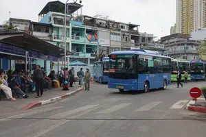
Ms. Nguyen Thanh Thao, who shared her experience of the underground space at Ben Thanh Metro Station of Ho Chi Minh City’s Metro Line 1 (Ben Thanh–Suoi Tien), from Hanh Thong Ward, said the underground space at Ben Thanh Metro Station is modern, cool, and relatively quiet, offering commuters a comfortable and orderly environment. It is not just a transportation facility but also contributes to transforming the urban landscape of Ho Chi Minh City, moving towards a modern and sustainable city. The city needs to develop more underground projects to help reduce traffic congestion and gridlock.
According to Mr. Nguyen Cong Tuan, a real estate investor in Ho Chi Minh City, underground spatial planning not only promotes the development of public transportation projects but also helps alleviate constraints in existing residential areas. He noted that underground planning provides a basis for granting permits for private houses with basement levels.
Architect Khuong Van Muoi, former Vice Chairman of the Vietnam Association of Architects, stated that Ho Chi Minh City’s orientation toward developing underground spaces and transportation is an inevitable path amid increasing traffic congestion and inadequate existing infrastructure.
He emphasized that effective use of underground space would bring numerous economic benefits to the city and better serve its residents. The key to utilizing underground space efficiently is having prior planning to ensure it is not encroached upon by above-ground structures. This allows for the creation of a continuous, integrated space that connects transportation facilities.
In addition, Ho Chi Minh City has certain areas, particularly in the city center, where demand for transportation, recreation, and entertainment is relatively high. However, meeting this demand is often hindered by existing structures and the high costs of land clearance and compensation. Therefore, focusing on the development of underground projects encourages greater participation from investors.
Dr. Nguyen Huu Nguyen from the Ho Chi Minh City Urban Planning and Development Association stated that for the city to utilize underground space effectively, it must conduct a thorough survey and research by geologists. The initial step is zoning, as each area presents different challenges and opportunities. Accordingly, Ho Chi Minh City can be divided into regions such as Binh Duong, Ba Ria–Vung Tau, northern HCMC, and the central area. Each area can be developed differently with specific purposes, and an underground map must be created. This will provide a solid foundation for effective planning and utilization of subterranean space.
If Ho Chi Minh City executes its planning well, the utilization of underground space will be highly effective. At present, the city already possesses sufficient technical capabilities, technology, and practical experience from underground projects such as the Thu Thiem tunnel and Metro Line 1 (Ben Thanh–Suoi Tien), he added.