Winds have currently reached level 12 (118 - 133 kmp), and are expected to intensify to level 13 (134 – 149 kmp) with gusts up to level 15. The storm is moving westward at a speed of approximately 20 kilometers per hour.
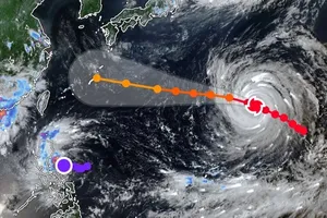
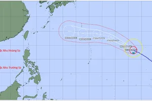
Early on August 24, the National Center for Hydro-Meteorological Forecasting reported that as of 4:00 a.m., the eye of Typhoon Kajiki was located at approximately 17.6 degrees North latitude and 111.7 degrees East longitude, over the northern waters of the Hoang Sa (Paracel) Islands. The storm was situated about 660 kilometers east-southeast of Nghe An Province and approximately 640 kilometers east of Ha Tinh Province.
The National Center for Hydro-Meteorological Forecasting reported that over the next 24 to 60 hours, the typhoon is expected to move in a west-northwest direction at a speed of approximately 20 kilometers per hour. By early morning on August 25, the eye of the storm is forecasted to be located in the southern area of the Gulf of Tonkin, about 230 kilometers from the coast of Nghe An Province and approximately 210 kilometers east of Ha Tinh Province. At this time, the storm's core is projected to maintain intensity between categories 12 and 13, with gusts reaching up to level 15.

Early this morning, the northwestern area of the East Sea experienced strong winds ranging from level 8 (62-74 kmp) to 10 (89- 102 kmp), with winds near the storm’s center reaching level 11 to 13, accompanied by gusts up to level 15. Waves were reported to be 5 to 7 meters high, rising to 7 to 9 meters near the eye of the storm, causing extremely rough sea conditions.
According to Mr. Mai Van Khiem, Director of the National Center for Hydro-Meteorological Forecasting, from noon through the afternoon today, the coastal waters stretching from Thanh Hoa to Hue City are expected to experience progressively strengthening winds, reaching levels 6 to 8, then intensifying to levels 9 to 10. Near the eye of the storm, winds are projected to reach levels 11 to 13, with gusts up to level 15. Wave heights are forecasted at 4 to 6 meters, increasing to 7 to 9 meters near the storm’s center.
At the same time, the northern part of the Gulf of Tonkin is experiencing strong winds of levels 6 to 7, with gusts reaching level 9. The southern part of this area is seeing winds at level 8, with gusts up to level 10. Wave heights range from 2 to 4 meters, causing rough sea. Along the coastal strip from Ninh Binh to northern Quang Tri, water levels have risen by 0.5 to 1.5 meters, posing a significant risk of flooding in low-lying and coastal areas, river mouths, and islands.
According to meteorological experts, the eye of the typhoon is expected to make landfall in the North Central region around midday to the afternoon of August 25. The storm’s core will primarily impact the North Central region. However, heavy rain and strong winds are forecast to begin intensifying as early as tomorrow morning.
On land, from tonight, August 24, the area stretching from Thanh Hoa to Quang Tri is expected to experience strong winds ranging from levels 7 to 9, increasing to levels 10 to 12 near the storm’s eye, with gusts reaching levels 14 to 15. Along the coastal strip from Quang Ninh to Ninh Binh, winds will be strong at levels 6 to 7, with gusts up to level 8.
The meteorological agency has issued a warning that from the night of August 24 through August 26, the Red River Delta, southern Phu Tho, and the area from Thanh Hoa to Hue will experience heavy rainfall ranging from 100 to 150 millimeters, with some locations exceeding 250 millimeters. Specifically, the region from Thanh Hoa to northern Quang Tri is forecast to receive 200 to 400 millimeters of rain, with localized areas potentially exceeding 700 millimeters.
Starting from August 25, Hanoi and Da Nang are expected to experience moderate to heavy rain accompanied by thunderstorms. Ho Chi Minh City will see scattered showers and thunderstorms in the late afternoon and evening. Meanwhile, Central Laos and Upper Laos are forecast to receive heavy rainfall from August 25 to 27, with totals generally ranging from 100 to 250 millimeters and localized areas exceeding 500 millimeters.