Traffic lanes narrowed, vehicles backed up
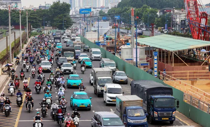
To facilitate the installation of barriers and ensure construction conditions for Ba Queo Station (ST9) under Ho Chi Minh City’s Metro Line 2 (Ben Thanh–Tham Luong) project, traffic arrangements on Truong Chinh, Tan Ky Tan Quy, and Huynh Van Gam streets have been adjusted.
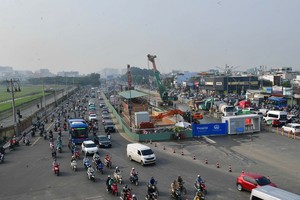
A survey on the morning of September 16 found that between around 7 a.m. and 9 a.m., the volume of traffic traveling from the city’s northwestern gateway toward central Ho Chi Minh City rose sharply. On Truong Chinh Street, near the Cong Hoa intersection, part of the roadway was cordoned off for construction, forcing vehicles into the remaining lanes. Motorcycles and cars formed long queues and moved slowly, with congestion at times stretching for more than 1 kilometer.
Traffic on Huynh Van Gam Street also increased significantly, particularly during peak hours when residents were commuting to work and taking their children to school.
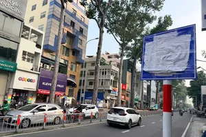
The traffic diversions have also affected local businesses, making it more difficult to stop and park vehicles and to load and unload goods.
Meanwhile, Nguyen Thi Thuy, a resident of the Che Lan Vien–Truong Chinh area, called for a survey of schools located on or near the diverted routes so that appropriate student pick-up and drop-off areas can be arranged, helping prevent congestion at the beginning and end of school hours.
Tran Quang Thang, a driver on Bus Route 27 running from An Suong Bus Station to Saigon Bus Station, said traffic frequently moves slowly because the roadway has been narrowed, particularly during peak hours when traffic volumes are high. Due to the bus’s large size, changing direction or diverting onto smaller roads can be difficult when congestion occurs. Thang suggested that during construction, authorities consider relocating bus stops in areas that frequently experience congestion.
Digital maps enable rapid response to traffic congestion
The Ban Co Traffic Police Team under the Road and Railway Traffic Police Division (PC08) of the Ho Chi Minh City Public Security Department is piloting a “Digital Map for Rapid Response to Traffic Congestion” as part of a campaign to encourage public participation in maintaining traffic order and safety.
Built on the Google Maps platform, the system integrates nine layers of data, including ward boundaries, coordinated boundary routes, locations of traffic command posts operated by traffic police and ward police, and a network of surveillance cameras. The system enables commanders to monitor traffic conditions visually, identify congestion hotspots, and deploy personnel to address them.
When congestion is detected, the unit’s command staff and duty officers can access camera footage to assess the situation and then dispatch personnel to the site to regulate traffic and ease congestion.
Notably, the model also engages local residents and businesses in providing information by sharing images from cameras at business establishments and households facing onto roads in key areas. This helps supplement real-time data and shorten the time needed to detect and address traffic congestion.
More than 15 streets affected
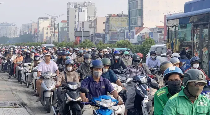
To facilitate the construction of Ho Chi Minh City’s Metro Line 2 (Ben Thanh–Tham Luong), the city will adjust traffic arrangements, install barriers, and restrict vehicles on multiple streets.
In the area around Tao Dan Station (ST2), the section of Cach Mang Thang Tam Street between Nguyen Du and Nguyen Thi Minh Khai streets, as well as the section of Nguyen Thi Minh Khai Street between Cao Thang and Huyen Tran Cong Chua streets, will be converted to one-way traffic. Song Nguyen Anh and Bui Thi Xuan streets will allow two-way traffic to help distribute vehicle flows.
Huyen Tran Cong Chua, Thu Khoa Huan, Le Thanh Ton, Pham Hong Thai, Truong Dinh, Vo Van Tan, Nguyen Dinh Chieu, and Cao Thang streets will be used as alternative routes.
Construction of Bay Hien Station (ST7) will affect Cach Mang Thang Tam, Truong Chinh, Ly Thuong Kiet, and Hoang Van Thu streets, with traffic restricted in certain directions. Similarly, the section of Cach Mang Thang Tam Street between Bay Hien Intersection and Cong Truong Dan Chu Roundabout will be adjusted to facilitate construction of Le Thi Rieng Station (ST5).
Including roads designated as alternative routes, more than 15 streets are currently or expected to be affected by traffic arrangements for the construction of Metro Line 2.
Mr. Nguyen Anh Tuan, a transport expert at Vietnamese-German University, said traffic arrangements for Metro Line 2 construction must take into account the capacity of the entire surrounding road network. When a main corridor is narrowed, traffic will shift to nearby routes; if alternative roads have limited capacity, congestion can emerge at new locations.
Authorities need to divert traffic from a distance, regulate flows based on actual travel patterns, and coordinate adjustments to traffic signal cycles. Traffic management plans should also be regularly updated based on daily traffic data, allowing timely adjustments to routes, signal timing, and traffic-regulation personnel and preventing congestion from simply shifting from one road to another.
Speaking to Sai Gon Giai Phong (SGGP) Newspaper reporters, Vo Khanh Hung, Deputy Director of the Ho Chi Minh City Department of Construction, said the traffic diversion plan was developed based on existing infrastructure, traffic volumes, and safety requirements during construction.
During the initial implementation period, authorities will closely monitor traffic conditions in each area, particularly along designated alternative routes. Data from surveillance cameras, traffic volumes, and actual conditions at intersections will be used to assess the effectiveness of the traffic diversion plan. If localized congestion occurs or new conflict points emerge, relevant agencies will coordinate to review and adjust the plan as necessary.
Traffic arrangements revised for construction of three Metro Line 2 stations:
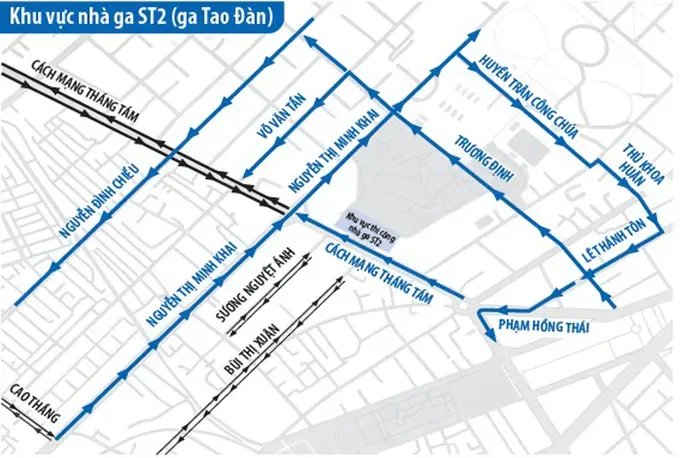
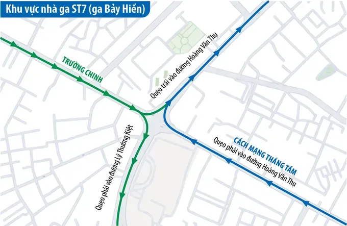
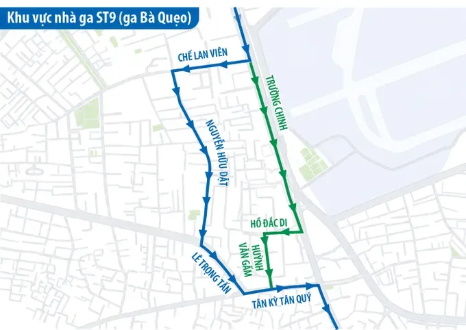

According to Vu Van Vinh, Director of Project Management Board 2 under the Ho Chi Minh City Urban Railway Management Board, traffic regulation around Metro Line 2 station construction sites is being carried out through on-site traffic diversions aimed at maintaining vehicle circulation while ensuring construction progress. Construction is currently underway at five underground station sites.
At these locations, contractors have arranged traffic diversions based on the principle of allowing vehicles to continue traveling through the construction areas. As the roadway available for traffic has been narrowed compared with existing conditions, the traffic management plan also provides for redirecting vehicles onto nearby roads. This is intended to ease pressure around the station sites and reduce the risk of congestion when traffic volumes increase.
At some locations, traffic arrangements involve restricting certain types of vehicles on existing roads and directing them onto nearby routes. For example, the section from Bay Hien Intersection to Cong Truong Dan Chu Roundabout will restrict cars, except buses. Vehicles will be directed via Hoang Van Thu and Le Binh streets toward the Nhieu Loc–Thi Nghe Canal area. Additional U-turn points have also been established to facilitate traffic movements.
In the coming period, Project Management Board 2 will continue coordinating with the Road and Railway Traffic Police Division (PC08) under the Ho Chi Minh City Public Security Department, traffic police teams, and ward police to regulate traffic. Cameras will also be installed at intersections to continuously monitor traffic conditions, enabling authorities to promptly regulate traffic remotely when congestion occurs and help maintain smooth traffic flows during Metro Line 2 construction.

According to Assoc. Prof. Dr. Ho Thanh Phong, former Rector of the International University under Vietnam National University - Ho Chi Minh City, traffic diversion plans must be assessed across the entire road network. Authorities must first determine where traffic originates and where it is headed, rather than simply counting the number of vehicles passing a particular point. While cameras can record traffic volumes at a given cross-section, they do not fully capture vehicle journeys. The scope of analysis should also extend to at least two layers of surrounding intersections around the location where an intervention is planned.
Authorities also need to take into account how road users are likely to respond. When a road is converted to one-way traffic or traffic flows are diverted, people will adjust their routes accordingly. A plan that appears reasonable in a model may still cause confusion and create conflicts in practice if road users are given unclear directions or required to make multiple complicated maneuvers.
Data and artificial intelligence (AI) can help identify patterns of congestion by combining camera footage with anonymized journey data from buses, ride-hailing vehicles, and other means of transport. Simulation models can then be used to assess “if-then” scenarios before a traffic management plan is implemented on the ground.
However, such models must accurately reflect the characteristics of mixed traffic and the high proportion of motorcycles in Vietnam. AI can also help detect incidents at an early stage and adjust traffic signals based on actual traffic density. Such adjustments should be coordinated across entire road corridors or areas rather than optimizing individual intersections in isolation.
Ho Chi Minh City should move toward developing a shared traffic data model that is continuously updated. Every traffic diversion plan should be simulated beforehand, evaluated after implementation, and subject to clearly defined criteria for adjustment or suspension. This would enable the city to move from addressing congestion at individual locations to managing traffic based on data across the entire road network.





)