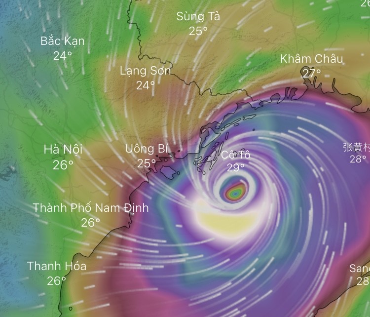
At 10:40 a.m., an update from Hai Phong reported intensified winds causing trees to sway, though the wind direction remained westerly. According to meteorologists, this suggests that the typhoon's eye had yet to make landfall.
In an interview with the press at 9 a.m. on September 7, Mr. Nguyen Van Huong, Head of the Forecasting Department at the National Center for Hydro-Meteorological Forecasting, stated that the typhoon was maintaining wind speeds of level 14 (150-166 km/h) as it advanced toward Northern Vietnam.
Meanwhile, Mr. Mai Van Khiem, Director of the National Center for Hydro-Meteorological Forecasting, indicated that Super Typhoon Yagi was nearing the area between Hai Phong and Quang Ninh. By 10:20 a.m. on September 7, 2024, strong winds had been recorded in several locations, including Co To Island (Quang Ninh) at level 12 with gusts up to level 15, Cua Ong (Quang Ninh) at level 12 with gusts up to level 14, Hai Phong City at level 7 with gusts up to level 9, Thai Binh at level 7 with gusts up to level 10, and Hai Duong City at level 6 with gusts up to level 8.

Mr. Nguyen Van Huong forecasted that from the afternoon to evening, the typhoon could make landfall, potentially bringing winds of levels 10-12 (89-133km/h) to the areas of Quang Ninh, Thai Binh, and Nam Dinh, with further impacts extending to Lang Son, Bac Ninh, and Bac Giang provinces.
In Hanoi, the typhoon is expected to bring gusts of levels 6-10 from the afternoon into the evening, along with heavy rainfall ranging from 150mm to 350mm.
"People should limit outdoor activities and be mindful of the risks posed by thunderstorms and heavy rain. Strong winds may cause trees to fall," warned Mr. Nguyen Van Huong.
Heavy rainfall could result in flooding in Quang Ninh, Hai Phong, and Hanoi.







)


