On the morning of July 9, the National Center for Hydro-Meteorological Forecasting said super typhoon Bavi is not expected to move into the East Sea. The agency had previously estimated the probability of the storm entering the East Sea at less than 10 percent.
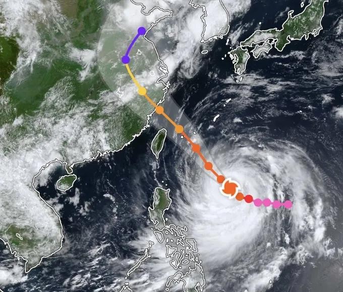
As of 7 a.m. on July 9, the center of super typhoon Bavi was located near 18.3 degrees north latitude and 130 degrees east longitude, about 810 km east of Luzon in the Philippines, around 1,100 km southeast of Taiwan (China), and approximately 1,400 km southeast of Fujian Province (China). The storm was packing sustained winds at the lower end of category 16 (184-201 km/h), with gusts exceeding category 17 (202–221 km/h).
Over the next 24 hours, typhoon Bavi is forecast to continue moving northwest at about 20 kph while maintaining super typhoon strength. Beginning July 10, the storm is expected to pass north of Taiwan before weakening to category 15, with gusts above category 17.
By the afternoon and evening of July 11, the super typhoon is forecast to make landfall in eastern Fujian Province with winds of category 13-14 before moving farther inland and continuing to weaken.
Although the storm is not expected to enter the East Sea, its circulation will still affect marine weather. From July 9, southwesterly winds over the southern East Sea, including waters around the Truong Sa (Spratly) archipelago, are expected to strengthen to category 6. On July 10 and 11, strong category 6-7 winds, waves of 3-5 meters, and very rough seas are forecast across the northern, central, and southern East Sea, including waters around the Hoang Sa (Paracel) and Truong Sa (Spratly) archipelagos.
The National Center for Hydro-Meteorological Forecasting said it will continue to closely monitor the development of super typhoon Bavi.