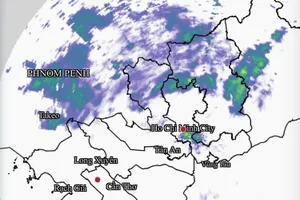
, based on the ECMWF model.(Source: WINDY)")
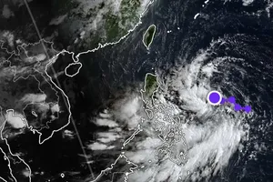
Updated data from international meteorological models on the morning of August 22 indicated that a low-pressure system east of the Philippines is moving rapidly toward the East Sea, with a 60–70 percent chance of intensifying into a storm.
Projections suggest the storm’s center is most likely to head toward the North-Central Coast, with a potential direct impact on Vietnam’s mainland between August 24 and 25.
")
")
The system’s circulation is expected to bring increasingly strong winds and worsening weather to the northern and central parts of the East Sea, including the Hoang Sa (Paracel) Islands and the Gulf of Tonkin. Vessels operating in hazardous areas have been urged to seek safe shelter without delay.
From August 25 onward, Northern Vietnam and provinces from Thanh Hoa to Hue may experience widespread moderate to heavy rainfall, raising risks of flash floods and landslides.
")
According to the National Center for Hydro-Meteorological Forecasting, the low-pressure system formed on August 21 over waters east of the Philippines and has been tracking west-northwest at speeds of 15–20 km per hour. The Vietnamese meteorological agency has advised residents, particularly those in coastal areas of Northern and North-Central provinces, to closely monitor forecast updates and take proactive safety measures.


)