According to the HCMC People’s Committee, there is still a limit in the application of the Geographic Information System (GIS) to provide information in district level, besides land management and urban planning, due to a lack of shared digital map services in the city.
Meanwhile, regulations on map service use or integrated mechanisms for map sharing are not sufficient enough. Therefore, most applications only exploit the existing maps like GoogleMaps or foundation map service, which might show inconsistency.
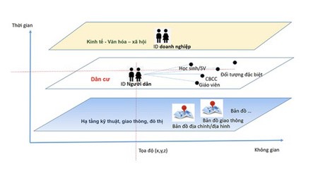
As a result, the HCMC Department of Information and Communications decided to pilot a shared digital map, aiming at forming a common database integrating datasets which consist of the master data about residents, businesses, and digital maps; the code database; and the reference data. These pieces of information are real-time data about citizen status (birthday, development process, job); property and land ownership; traffic; certificates and permits; events and issues in HCMC.
This special map service, which is a part of the HCM Local Government Service Platform (HCM LGSP), is critical for other applications to refer and save additional data, creating a precise and united Geocode. This is the foundation for new integrated geographic information layers.
Ms. Vo Thi Trung Trinh, Deputy Director of the HCMC Department of Information and Communications, stated that from now until June 2020, the city is piloting integrating certain approved geographic information into one shared digital map.
Via this map, HCMC residents and businesses can easily look up detailed information about various aspects. For instance, a medical company can use the map to identify the correct number and locations of clinics operating in the city and make a better decision on where to build a new one. Similarly, citizens can access the map to seek the most prestigious medical services they need.
HCMC established the goal until 2020, with a vision to 2025, to successfully run certain common databases, including this important digital map, so that precise and updated information can be accessible to the general public as well as state offices.
The shared digital map is created via two main phases. In the first one, HCMC hires a background map from a map developer and evaluates its effectiveness. Based on that basic map, more necessary information layers will be added as long as it is approved by state specialists. This adjusted map will be used in the initial stage.
In the second phase, after the HCMC Department of Natural Resources and Environment finishes the projects ‘Editing Changes in Cadastral Maps and Building Cadastral Document System for Land Management in HCMC’ and ‘Constructing Database for Founding Geographic Information in Ratio of 1/2000, 1/5000 in HCMC’, the above adjusted map will be regularly updated while this department will cooperate with the HCMC People’s Committee to form a complete shared digital map for the city.
