The National Center for Hydro-Meteorological Forecasting reported that the Northwest region, the Central Highlands region, and the South region continued to experience localized thunderstorms on September 13. The heaviest rainfall was recorded in Tuyen Quang Province (228mm) and Lao Cai Province (240mm). In Bao Yen Commune of Lao Cai Province, heavy rain caused mud and rocks to flow into residential areas in Ba Thau hamlet, leading to flooding in rice fields and destruction of crops.
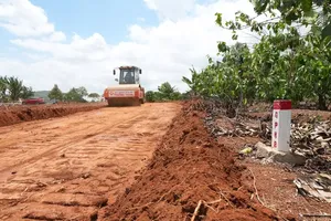
A section of the road from the center of Bao Yen Commune to Nul village on the National Highway 70 experienced localized flooding and landslides. On the National Highway 70, there were areas completely covered in mud, posing a danger to traffic.
Immediately, local authorities mobilized machinery to clear the roads and restore access.
Additionally, at the entrance of the Trai Hut temple, located on Provincial Road 163 in An Binh Commune of Lao Cai Province, a deep hole appeared on the asphalt road after floodwater receded. Local authorities have cordoned off this hazardous area pending repairs.
Meanwhile, in Tuyen Quang Province, flooding continued to cause damage in the communes of Yen Phu, Phu Luu, Cao Bo, Thuan Hoa, and Binh Xa. Several roads were inundated, creating hazards for motorists. The Tuyen Quang provincial police, along with local security teams and residents, organized forces to monitor and warn about dangerous areas; they mobilized machinery and manpower to assist in leveling, transporting, and relocating assets for affected households.
Principal Nguyen Thien Ha of Thang Tin Ethnic Boarding Primary and Secondary School in Tuyen Quang Province, reported that after three days of efforts to address the aftermath of the heavy rain and flooding, 301 students from the school have now returned to their classrooms. Previously, during the night of September 9 to the morning of September 10, intense rainfall caused mud and debris to cover the schoolyard and some classroom floors, as well as the boarding area.
Vice Chairman Duong Mah Tiep of the Gia Lai Provincial People's Committee yesterday instructed that communes and wards in at-risk areas conduct a thorough assessment of all residential zones situated along rivers, streams, mountain slopes, steep inclines, and coastlines that are susceptible to landslides. This is to formulate response strategies and facilitate the evacuation of residents in the event of natural disasters. Concurrently, local authorities are required to enhance and utilize information technology to effectively implement flood prevention measures, particularly in critical sites and remote regions.

In an effort to mitigate the impact of natural disasters, the Provincial People's Committee has directed investors and construction contractors, particularly those working on transportation projects, to develop and implement proactive strategies. These include securing construction sites and establishing dedicated emergency response teams to address any crisis situations that may arise.
According to the Gia Lai Province Department of Agriculture and Environment, 135 communes and wards across the province are highly susceptible to storms and natural disasters, with 40 of these being at risk of landslides. The eastern region is particularly vulnerable, with 28 serious landslide sites. Fifteen of these locations require frequent emergency evacuation plans during periods of heavy rain and flooding. Additionally, many traffic routes traversing mountainous terrain and mining areas are prone to landslides, posing a significant threat to safety during the rainy season.
In a related development, the Quang Ngai Department of Construction announced a plan to inspect traffic infrastructure in the western part of the province for damage from storms and floods. From September 17 to 19, an inspection team will survey 15 national and provincial roads, as well as other routes under the department's management. The survey will cover 21 mountainous and border communes to assess the extent of the damage, identify areas needing repair, and propose solutions to ensure safe and unimpeded traffic flow.
It has been observed that many roads in the western part of the province have sustained significant damage, creating hazards for motorists. For example, a section of the Ngoc Hoang - Mang But - Tu Mo Rong - Ngoc Linh road, which passes through Mang Ri Commune, has been severely eroded. This has caused the roadbed to collapse, leaving only a narrow lane for vehicles and putting the road at risk of a complete break with continued heavy rainfall. Chairman Pham Xuan Quang of the People's Committee of Mang Ri Commune stated that the damage has made the road impassable for large trucks and has hindered the transport of agricultural products.
Furthermore, a landslide at the Mang Roi Pass bypass has deposited rocks and soil onto the road surface, with more debris threatening to fall. On provincial road 673 (from Dak Plo to Xop and Ngoc Linh communes), several landslides have created large 'frog jaws', which pose a serious risk of the road surface collapsing.