Ho Chi Minh City is steering away from further high-rise apartment development in the central area, instead prioritizing the expansion of parks, public spaces and community-oriented amenities.

Speaking to SGGP Newspaper, Director Truong Trung Kien of the Ho Chi Minh City Department of Planning and Architecture outlined the city’s upcoming strategy for organizing urban space in the downtown core.
According to Director Truong Trung Kien, the current central area of Ho Chi Minh City is designated as the historical, administrative, commercial, service, cultural and tourism core at the municipal, regional and national levels. Under Decision 1125/QD-TTg, the city is being developed under a multi-center urban model, in which the existing downtown area belongs to the central urban subregion covering about 172 square kilometers, with a projected population of 5.4 million - 6.05 million people by 2040.
Under the master plan, the area is intended for urban renovation, redevelopment, architectural heritage preservation, expansion of open spaces and greenery, and development of public spaces, commerce, services and public transportation. The city’s master plan also emphasizes urban renewal and redevelopment, preservation and revitalization of the downtown core within Ring Road 2, while controlling residential density in line with the capacity of technical and social infrastructure. The policy is aimed at reducing pressure on existing infrastructure while prioritizing parks and public spaces serving the community.
The director revealed that the Ho Chi Minh City Department of Planning and Architecture is advising the Ho Chi Minh City People’s Committee to strictly control adjustments that would increase infrastructure pressure in the downtown core. Criteria such as population density, land-use ratio, building height, construction density, parking areas and public spaces will be key conditions when considering planning adjustments or approving projects. Projects in the central area, if approved, must prioritize urban renovation, creation of open spaces, heritage preservation, public transport connectivity, green buildings and parks within project grounds.
In addition, high-rise housing will be considered in areas with strong infrastructure connections to ring roads, major public transportation corridors or TOD areas (Transit-Oriented Development). This aligns with the broader planning direction of developing regional urban centers and satellite cities to ease pressure on the city center.
Mr. Truong Trung Kien said that under Decision 1125/QD-TTg, Ho Chi Minh City is organized into six main subregions including the central urban subregion, Eastern, Western, Northern, Southern and Southeastern subregions. These subregions are connected through nine radial corridors, three ring roads and new development corridors.
The Eastern area is planned as a hub for innovation, education, training, finance, healthcare, eco-tourism and high technology. Key centers include Thu Thiem, Truong Tho, Rach Chiec, Long Phuoc and Tam Da, making the area suitable for housing development linked to metro lines, high-tech zones, universities, services and financial centers.
The Western area is planned as an industrial, commercial, technology, healthcare service and education hub. The area still has significant room for new urban development linked to external transportation corridors, Ring Road 3, logistics zones, clean industrial parks and urban services.
The Northern area is associated with high-tech agriculture, clean industry, logistics, services and major transportation corridors. It is considered suitable for housing for workers, experts and laborers while reducing pressure on the urban core.
The Southern area will continue developing as a service, port, logistics, housing and commercial urban zone linked to Nguyen Van Linh Boulevard, the Nam Saigon urban area, Hiep Phuoc Port and transport routes connecting to the city center.
The Southeastern area is planned as an ecological zone, green lung, eco-tourism, marine economy, logistics and controlled coastal urban area. Housing development there must proceed cautiously in line with biosphere reserve protection, climate change adaptation and long-term integration with waterway, roadway and urban railway public transport systems.
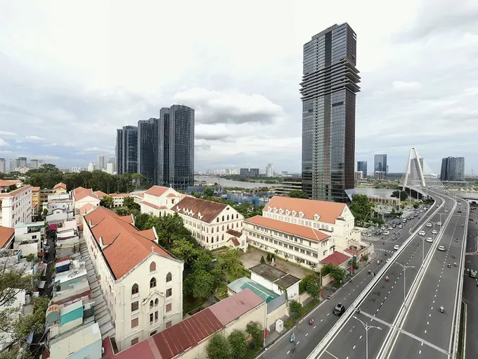
Regarding social housing and worker housing, the city is planning land allocation linked to TOD models, growth-driving zones and urban development areas, with around 20 percent of converted residential land area potentially reserved within TOD zones and other urban development areas.
Land reserves for apartment developments outside the city center are intended not only to decentralize population growth, but must also meet three conditions: proximity to public transportation, proximity to jobs or industrial zones, and sufficient schools, healthcare facilities, parks, commercial centers and synchronized urban services. Following administrative restructuring, Ho Chi Minh City will have additional capacity to organize and allocate residential areas to meet residents’ housing demand.
To implement this policy, he said, the Department of Planning and Architecture is reviewing and adjusting planning frameworks through the formulation and revision of master plans, general plans and subdivision plans to support new urban construction, urban redevelopment and the establishment of urban areas with synchronized technical and social infrastructure systems.
Based on approved plans, the city will review suitable locations for developing green spaces and parks. The goal is to establish a continuous network of green and public spaces linking rivers, canals and waterways with public parks to create an ecological network, drainage corridors and improved urban flood management.