") |
The forecasted direction of Storm Koinu (Photo: NCHF) |
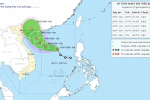
As of 7 a.m. on October 3, the storm's center was located around 20.5 degrees North latitude and 125.0 degrees East longitude, situated in the Northeastern sea near Luzon Island in the Philippines. The most intense winds near the storm's center were at level 15 (167-183 km/h), with gusts exceeding level 17. The storm was moving Northwestward at an approximate speed of 10 km/h. It is forecasted that, in the coming days, the storm could have an impact on the Northeastern East Sea region.
As of the afternoon update on October 2, the storm's center was located at approximately 19.7 degrees North latitude and 126.4 degrees East longitude, moving in a Northwest direction at a speed of about 15 kilometers per hour. The wind force near the storm’s center reached levels 14 to 15.
") |
Image of Storm Koinu from satellite (Photo: NCHF) |
On October 2, the National Center for Hydro-Meteorological Forecasting reported that the South Central, South Central Highlands, and the Southern region experienced varying degrees of rainfall due to the influence of the Southwest monsoon. It included moderate and heavy rain and, at times, even heavy to torrential rainfall, accompanied by thunderstorms. Rainfall data recorded until the afternoon of October 2 at measuring stations included 91.2mm in Hoc Mon (HCMC), 89mm in Gia Rai (Bac Lieu Province), and 188.8mm in Phu Tan (Ca Mau Province). It is worth noting that thunderstorms in the Southern region are expected to intensify again.