")
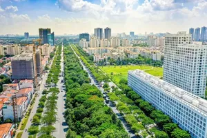
The draft Special Urban Law of 2026 is opening up a landmark institutional space, highly expected to create a breakthrough in untangling stubborn planning and administrative bottlenecks for HCMC. For the very first time, a multi-layered spatial management mindset (underground, ground level, low altitude, high altitude, and maritime zones) alongside dynamic urban operational models like TOD, the maritime economy, and the night-time economy have clearly emerged.
A sprawling megacity can’t be effectively managed without clearly jurisdictional boundaries across distinct spatial layers. Practical reality vividly demonstrates that developing a low-altitude economy to serve logistics using drones and flying taxis (eVTOL), or coastal land reclamation and underground space exploitation projects can easily fall into legal “blind spots” between the locality’s right to economic development and the Central Government’s rigid control over national defense and security.
To fundamentally solve this complex puzzle, the Special Urban Law should explicitly clarify jurisdictional authority right within its framework regulations. Accordingly, the 0-120m airspace (ultra-low altitude) should be handed over as a comprehensive package to the HCMC People’s Committee to manage and license civil activities alongside drone deliveries.
In the mixed airspace spanning from 120m to under 1,000m (the low-altitude zone of the HCMC megacity), the bustling city should take the lead in seamlessly coordinating with the Ministry of National Defense and the Ministry of Construction to establish an Urban Low-Altitude Air Traffic Management (UTM) system, operating strictly under the technical supervision of Military Region 7 and the Air Defense – Air Force Service.
Ultimately, clarifying these boundaries is undeniably the crucial key to transforming ambiguous “gray zones” into vibrant “green development zones,” helping investors feel perfectly secure while ensuring the absolute safety of the national defense posture.
Transitioning from a purely “static” urban governance method to a “dynamic, real-time operating” approach inherently demands a major data revolution. Spatial Data Infrastructure (SDI) must be rigorously legislated as an essential technical infrastructure and the core digital resource of this special megacity.
The pivotal crux for HCMC to maintain absolute technological autonomy, prevent security data leak risks, and avoid the “vendor lock-in” trap orchestrated by solution corporations is to comprehensively standardize everything in accordance with international criteria.
Every single Digital Twin or Building Information Modeling (BIM) system belonging to the city must strictly comply with Open Geospatial Consortium (OGC) standards such as WMS, WFS, and 3D Portrayal, alongside international ISO/TC 211 standards concerning geographic information, with prime examples being ISO 19115 (Metadata) or ISO 19152 (Land Administration Domain Model - LADM).
This internationally standardized open data platform will flawlessly allow data streams to interconnectedly flow from deep underground and the surface straight up to the sky. Furthermore, this serves as the core technical corridor for HCMC to strongly digitize ecological maps and apply remote sensing alongside IoT technologies to sustainably manage the sprawling green zones in Cu Chi, Can Gio, and Nha Be areas, paying particular attention to the Can Gio Mangrove Biosphere Reserve, an utterly unique natural treasure that no other megacity possesses.
When synchronously connected with the Nam Cat Tien national forest ecosystem in the Southeast region, this data infrastructure will forge a legal and scientific foundation to accurately measure and meticulously audit emission reserves and mangrove fluctuations. From there, authorities can operate a highly qualified carbon credit trading floor to connect and trade with the international financial market.
“When the Special Urban Law grants a vastly superior institutional framework, accurately concretizing it with an autonomous digital operating system anchored in OGC open platforms, rigorous ISO standards, and a synchronous river-sea economic strategy will undoubtedly act as the most robust launching pad. If we skillfully capitalize on our expanding waterways, geospatial data, and dynamic innovation, HCMC can absolutely transform into Southeast Asia’s very first digital riverine megacity.”
Assoc Prof Dr Le Trung Chon
It’d be a massive shortcoming if the digital operating system of a riverine city like HCMC completely neglected its sprawling water surface spaces. The intricate system of rivers and seaports should ideally be legislated as a core component within the integrated transportation system.
The city should be empowered to promulgate guiding documents to rigorously develop the Water Transit-Oriented Development (W-TOD) model along the Saigon and Dong Nai rivers. Essentially tailored for waterways, this model strategically develops urban areas tied to boat terminals. It’s been triumphantly deployed in Brisbane.
Concurrently, the waterway data network should interconnect with the Can Gio, Hiep Phuoc, and Cai Mep - Thi Vai ports. Accompanied by clean energy policies, green waterway logistics will effectively and drastically slash roadway pressure while lowering costs and shrinking carbon emissions across the region.
In the end, thoroughly exploiting this river network isn’t just an infrastructure solution; it’s the exact pathway propelling HCMC to rise as a model megacity pioneering sustainable development globally.