As reported by the weather agency, at 1 p.m. on September 23, water levels at Ta Lai Station had decreased very slowly to 112.47 meters, 0.03 meters below warning level 2.
In the next 24 hours, water levels at the station are forecast to remain unchanged above warning level 1, along with risks of flooding and riverbank erosion in low-lying areas of Tan Phu and Dinh Quan in Dong Nai Province and nearby areas.
The hydro-meteorological agency recommended residents and local authorities raise preventive cautions amid current unpredictable weather conditions, especially heavy rain combined with flooding, which can affect transportation, aquaculture and agricultural production.

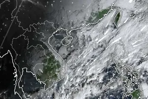
As the related weather news from the National Center for Hydrological and Meteorological Forecasting, the Central region has braced for extreme heavy rainfall of 150 mm above in the past 24 hours, primarily in Vinh City, Nghe An Province and Cuong Gian Commune, Nghi Xuan District in Ha Tinh Province.
The heavy rains have caused localized flooding, affecting residents’ life, dyke systems and irrigation works in the area.
The National Center for Hydro-Meteorological Forecasting predicted that from September 24, the frequency of heavy rain in the Central region will gradually decrease. However, localities should proactively monitor weather conditions and implement preventive measures to ensure the safety of dikes and communities in low-lying and residential areas.


