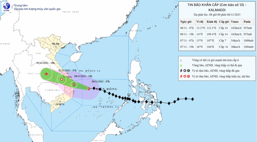
The National Center for Hydro-Meteorological Forecasting reported that as of 8 a.m. on November 6, the storm’s center was located at around 13.1 degrees North latitude and 112 degrees East longitude — approximately 310 kilometers east-southeast of Quy Nhon (Gia Lai). Maximum sustained winds near the storm’s center reached level 14 (150–166 km/h), with gusts up to level 17. Over the next three hours, the typhoon is expected to continue moving rapidly westward at about 25 km/h.
By 7 p.m. the same day, the storm’s center is forecast to be at 14.0 degrees North latitude and 109.4 degrees East longitude, just off the coast between Quang Ngai and Dak Lak, about 70–100 kilometers from shore. At that point, typhoon No.13 will remain extremely powerful, with sustained winds of levels 13–14 and gusts reaching level 17. The area near the storm’s eye will experience violent squalls and waves of 7–9 meters, with seas becoming very rough.
Between 9 p.m. and early November 7, the typhoon is expected to make direct landfall over provinces from Quang Ngai to Dak Lak. Winds in the storm’s core may reach levels 12–13, with gusts up to levels 15–16. The most severely affected areas are forecast to be eastern Quang Ngai and Gia Lai provinces.
After moving inland, the storm will weaken into a tropical depression, with wind speeds dropping to level 7 and gusts to level 9 over southern Laos by 7 a.m. on November 7.
Meteorologists warned that before the typhoon’s landfall, its outer circulation would already bring heavy rain and gusty winds, posing risks of whirlwinds and tornadoes.
Along coastal areas from Quang Ngai to Khanh Hoa, winds are expected to strengthen gradually to levels 8–11, with areas near the storm’s center reaching levels 12–14 and gusts up to level 17. Inland areas from southern Da Nang to Dak Lak will experience winds of levels 8–9, with gusts up to levels 14–15 near the storm’s core.

From this afternoon through tonight, torrential rains are forecast across Da Nang to Dak Lak, with rainfall ranging from 200 to 400 millimeters, and in some places exceeding 600 millimeters. Heavy to torrential rain is also expected from southern Quang Tri to Khanh Hoa, raising the risk of flash floods, landslides, and flooding in low-lying areas.
According to the Vietnam Meteorological and Hydrological Administration, typhoon Kalmaegi has a trajectory and intensity similar to typhoon Damrey in 2017 and typhoon Molave in 2020 — both of which were powerful systems that moved rapidly and caused widespread heavy rainfall across the central and Central Highlands regions.
The agency warned that all vessels currently operating within the danger zone must urgently seek safe shelter. Residents in areas directly affected by the storm are advised to reinforce their homes, avoid going outdoors during strong winds, and strictly follow instructions from local authorities.
