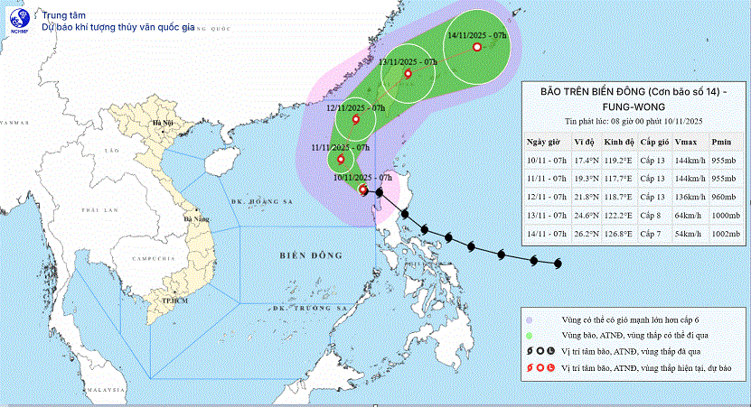
However, forecasters said that the system is expected to continuously change direction and gradually move out of the East Sea in the coming days.

According to the National Center for Hydro-Meteorological Forecasting (NCHMF), as of 7 a.m. on November 10, the storm’s center was located near 17.4 degrees North latitude and 119.2 degrees East longitude, over the eastern waters of the northern East Sea. Maximum sustained winds near the center were category 13 (equivalent to 134–149 kilometers per hour) with gusts reaching category 16. The storm is currently tracking west-northwest at about 15 kilometers per hour.
By tomorrow morning, November 11, Fung-wong is forecast to remain over the eastern part of the northern East Sea, maintaining category 13 strength with gusts up to category 16, moving northwest at 10–15 kilometers per hour.
By November 12 morning, the typhoon’s center will likely be over the northeastern waters of the northern East Sea, still packing category 13 before turning north-northeast at 10–15 kilometers per hour.
By November 13 morning, Fung-wong is expected to approach the northeastern coastal waters near Taiwan (China), weakening to category 8 (equivalent to 62–74 kilometers per hour) with gusts up to category 10, and moving northeast at 15–20 kilometers per hour.
Meteorologists warn that due to the storm’s influence, strong winds of category 8–10 will prevail over the eastern waters of the northern East Sea on November 10, increasing to category 11–13 with gusts up to category 16 near the storm’s center. Waves will rise five to eight meters, and up to eight to ten meters in the storm’s core area, creating extremely rough seas.
All vessels operating in these dangerous zones are recommenced to take extreme caution as severe thunderstorms and large waves are expected.


)


