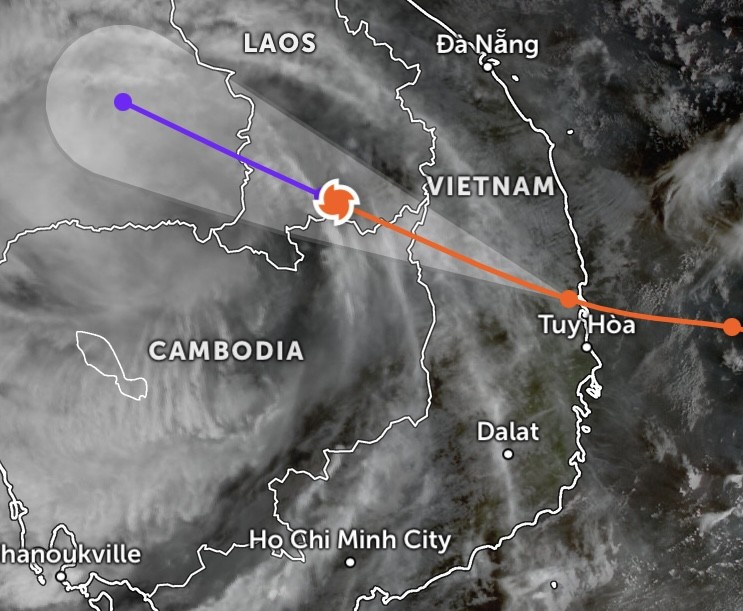
The storm moved inland across Gia Lai and Dak Lak provinces, unleashing widespread heavy rain and strong winds before rapidly losing strength on the night of November 6.
Mr. Mai Van Khiem, Director of the National Center for Hydro-Meteorological Forecasting, said that the storm’s circulation had weakened into a tropical depression by early morning on November 7. By 4 a.m. the same day, it had further dissipated as it tracked westward into southern Laos.
The national forecasting center reported that from this morning through midday, the low-pressure system will continue moving west-northwest and completely dissipate. Accordingly, the agency issued its final advisory on typhoon No.13.
Although the storm has dissipated, the center warned of continued risks of heavy rainfall, flooding, and landslides across Central Vietnam. Meteorological data show that from the night of November 6 to early November 7, provinces from Thua Thien Hue to Khanh Hoa recorded heavy to torrential rain, with rainfall in several areas exceeding 130 millimeters.
Some stations reported exceptionally high totals, including Son Hoi (Dak Lak) with 208 millimeters, Bach Ma Summit (Hue) 204 millimeters, Ba Na (Da Nang) 142 millimeters, Tra Thanh (Quang Ngai) 138.8 millimeters, and Tan An 2 (Gia Lai) 154.8 millimeters.

Over the next 24 to 48 hours, areas from southern Quang Tri to Da Nang and the Central Highlands are forecast to receive 20–50 millimeters of rainfall, with some localities exceeding 80 millimeters. From November 7 through November 8, heavier rains are expected from Thanh Hoa to northern Quang Tri, averaging 50–150 millimeters and locally topping 200 millimeters. The center warned of localized downpours exceeding 100 millimeters within three hours, heightening the risk of natural disasters.
While the Southern region is not directly affected by the storm, scattered showers and thunderstorms are expected late on November 7, with rainfall ranging from 10 to 30 millimeters and some areas exceeding 70 millimeters. Localized heavy rain over 60 millimeters in three hours is also possible.
According to the national forecasting center, from the night of November 8, rainfall over the area from Thanh Hoa to northern Quang Tri will gradually ease.
Floodwaters rising again on Huong River
The National Center for Hydro-Meteorological Forecasting reported that water levels on the Huong River in Hue City and the Tra Khuc River in Quang Ngai are rising due to heavy post-storm rainfall.
Over the next six hours, the flood level on the Tra Khuc River at the Tra Khuc station is expected to continue rising, peaking just below Level 3 (the highest warning threshold) before subsiding. Within the next 12 hours, water on the Huong River at the Kim Long Station will keep rising and remain 0.55 to 0.65 meters above Level 2, then gradually fall. During the following 12 to 24 hours, water levels on both rivers will slowly recede but remain elevated—above Level 2 on the Huong River and above Level 1 on the Tra Khuc River.
