This morning September 14, low-pressure zone resulted from typhoon Berijat centered at the coastal provinces of Quang Ninh to Hai Phong with wind speed at level 6.
Low-pressure zone causes rains in the northern region with total rainfall at 50 to 100mm. While super typhoon Mangkhut is predicted to move towards the East Sea on September 15 and become the 6th typhoon in the year.
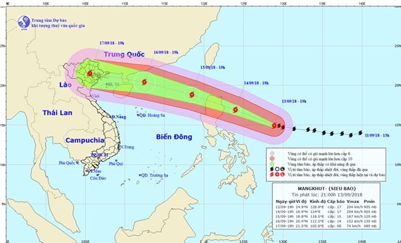
The center said yesterday, super typhoon centered at 14.7 degrees north latitude, 130 degrees east longitude. The strongest winds near the center reached level 17 equal to 200 to 220km per hour.
Super typhoon is forecast to move west west north at 20km per hour. In the next 24 to 48 hours, it will be able to change its direction to west north, at 25km per hour heading to the East Sea in China’s Hainan Island.
In the next 48 to 72 hours, super typhoon move west west north at 25km per hour and approaching near China’s Hainan Island.
Super typhoon Mangkhut will weaken as it approaches near China’s Hainan Island but the northern and north central Vietnam will suffer heavy rains due to the impact of typhoon Mangkhut on September 17 and 18.
The international weather centers predicted super typhoon Mangkhut may head to the northern delta on September 17 and Hanoi capital will be hit by the typhoon.
The National Steering Board for Natural Disaster Prevention and Control yesterday asked all forces in the coastal provinces of Quang Ninh to Binh Dinh to cooperated with authorities to call for vessels fishing at sea to move to shelters or safer places.
The southern region on these days is experiencing scattered rains and prolonged rains. Since September 12 to date, the southern central, central highlands and southern regions have been hitting by heavy rains and thunderstorms.
The rainfall in Quang Ngai has reached at 75mm (at Ba To Station), 63mm in Binh Dinh province’s Van Canh Station, 68mm in Dak Nong province’s Dak Mil Station, 67mm in Dong Nai province’s Long Khanh Station…


