Meanwhile, the Central Highlands and Southern areas will continue to see showers and thunderstorms in the afternoon and evening.
According to Deputy Director of the National Center for Hydro-Meteorological Forecasting, Hoang Phuc Lam, from September 1 to 7, the Northern region, Thanh Hoa and Nghe An will mainly experience sunny weather. Hanoi is forecast to enjoy sunny conditions on National Day, September 2. On the first day of the new school year, September 5, Hanoi and many northern localities are also highly likely to remain dry and sunny.
The Department of Meteorology and Hydrology said the Northern region will experience hot weather on September 1, with temperatures generally ranging from 35 degrees Celsius to 37 degrees Celsius and locally exceeding 37 degrees Celsius. In Hanoi, the highest temperatures are forecast at 34 degrees Celsius-36 degrees Celsius, with some areas above 36 degrees Celsius. The heat in the Northern area is expected to ease from September 2.
In the Central region, heavy rain is forecast from Ha Tinh to Da Nang during the afternoon and night of August 31, with rainfall generally reaching 20-40 mm and locally exceeding 80 mm. The heavy rain is expected to end on September 1.
From September 2, areas from Thanh Hoa to Da Nang will experience hot weather, with some places facing severe heat. Temperatures are forecast at 35 degrees Celsius to 37 degrees Celsius, with some areas exceeding 37 degrees Celsius. The heat in central Vietnam is likely to persist until around September 3 or 4.
According to the Southern Regional Hydro-Meteorological Station, weather conditions in Ho Chi Minh City are expected to be relatively favorable on September 1. The city will see sunshine from morning to noon, while showers and thunderstorms are forecast to begin around 3-4 p.m. Rain will gradually ease after 7-8 p.m. On the evening of September 2, when outdoor activities and fireworks displays are scheduled, the weather is forecast to remain dry.
In Can Tho and Vinh Long, September 1 will bring sunny conditions in the morning, with temperatures ranging from 26 degrees Celsius to 34 degrees Celsius. Thunderstorms are expected in the afternoon, but rainfall is forecast to be light and short-lived.
In Tay Ninh and Dong Thap, there will be little rain in the morning and at noon on September 1, providing favorable conditions for outdoor activities. Showers and thunderstorms are expected in the afternoon and evening.
On September 2, rainfall is forecast to increase and occur earlier, from noon through the afternoon and evening. Rain will gradually ease after 6 p.m., making nighttime activities relatively favorable.
In Dong Nai and Lam Dong, rainfall is expected to ease slightly on September 1 and 2. Cloud cover will decrease during the day, with sunny spells developing. Afternoon and evening showers and thunderstorms are expected to become more localized, with heavy rain occurring only in isolated areas. Da Lat, coastal areas, and Phan Thiet are forecast to remain relatively cool and pleasant.
In An Giang and Ca Mau, weather conditions are expected to be relatively favorable with little rain on September 1. Rainfall will increase from the night of September 1, beginning earlier in coastal areas of An Giang before spreading toward Ca Mau and northward. The western border area of An Giang is expected to see little rain, mainly light showers.
Tropical depression heads toward the northern East Sea
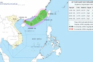
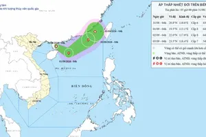
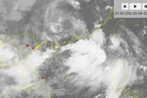
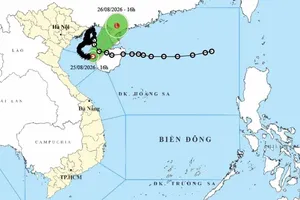
As of the afternoon of August 31, a tropical depression over China's Hainan Island was moving toward the northern East Sea and could strengthen into a storm.
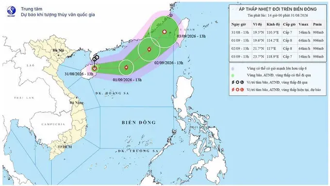
According to the National Center for Hydro-Meteorological Forecasting, the center of the tropical depression was located at around 19.5 degrees North latitude and 110.3 degrees East latitude over China's Hainan Island.
Maximum sustained winds near the center were at level 7 (50–61 km/h), with gusts reaching level 9 (75–88 km/h). The system was moving southward at approximately 15 km/h.
On September 1, the tropical depression is forecast to move eastward at 15- 20 km/h, entering the northern waters of the northern East Sea and potentially strengthening into a level 8 (62–74 km/h) storm, with gusts reaching level 10 (89–102 km/h).
By September 2, the storm is expected to move northeastward at 15-20 km/h toward the northeastern waters of the northern East Sea. It is forecast to maintain level 8 intensity, with gusts reaching level 10.
Over the following 48 to 72 hours, the storm is forecast to continue moving northeastward at around 10 km/h before gradually weakening into a tropical depression.