The Government issued Resolution 120 on the sustainable development of the Mekong Delta in response to climate change. Additionally, many scientists and residents have offered suggestions and solutions to help the Mekong Delta overcome these challenges.
Proactively planning for response
Mr. Nguyen Ngoc He, Vice Chairman of the Can Tho City People's Committee, reported that Can Tho experienced two instances of saltwater intrusion via the Hau River reaching Cai Cui Port in Tan Phu Ward, Cai Rang District (bordering Hau Giang Province) in 2016 and 2020. This demonstrates the increasingly severe impacts of climate change, natural disasters, and human-made factors, such as the operation of upstream hydroelectric dams and reservoirs.
To proactively prevent and adapt to drought, water shortages, and saltwater intrusion, the city has focused on effective forecasting and timely, accurate communication to authorities at all levels, enabling residents to respond proactively. The city also ensures the proper operation of irrigation systems and develops scenarios for response and adaptation to drought, water shortages, and saltwater intrusion based on the specific conditions of each district.
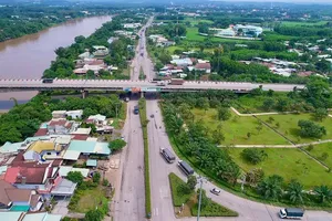
Many other localities have also constructed water canal systems and major salinity prevention projects, such as the Quan Lo - Phung Hiep irrigation system, the freshwater and salinity prevention irrigation system in Ben Tre Province, the Ba Lai sluice gate, the Cai Lon - Cai Be canal, and the coastal dyke system.
Additionally, they have focused on reviewing roads along rivers, canals, and creeks at risk of erosion and subsidence, installing warning signs, and implementing appropriate measures to minimize damage. Residents are mobilized to participate in preventing damage from subsidence and landslides and addressing areas that pose safety risks to people and vehicles.
The rice-shrimp farming model is considered a smart, nature-friendly agricultural practice that adapts to climate change. In regions prone to saltwater intrusion, farmers capitalize on the six-month rainy season to implement rice-shrimp rotational farming. This farming method is prevalent in provinces like Kien Giang, Ca Mau, Bac Lieu, and Soc Trang. In some areas, residents have proactively invested in plastic bags to store rainwater and dredged canals, ditches, and ponds, lining them with plastic sheets to retain water. These initiatives not only withstand salinity challenges but also enhance income levels.
Enthusiastic recommendations
From a scientific standpoint, numerous researchers have delved into the current situation and proposed solutions to address the challenges in the Mekong Delta. Associate Professor - Dr. Le Anh Tuan, former Vice Director of the Research Institute for Climate Change at Can Tho University, advocates for the efficient use of surface water with ensured quality instead of the current trend of excessive groundwater extraction.
According to Dr. Le Anh Tuan, the gradual transition from groundwater to surface water for domestic use is crucial in the current circumstances. However, before undertaking this transition, careful consideration must be given to the source of surface water and the treatment technology employed, as it will impact the cost price and the affordability of residents.
"In addition, it is important to consider the compatibility and flexibility in accessing both surface water and groundwater sources. During the rainy season, when surface water is plentiful and of good quality, it should be prioritized for use. However, during the dry season when saltwater intrusion is severe and surface water is contaminated, groundwater should be used sparingly," stated Associate Professor - Dr. Le Anh Tuan.
Mr. Ho Thanh Phuong, Director of the Department of Natural Resources and Environment of Dong Thap Province, announced that the province was devising a plan to shift from groundwater extraction to surface water utilization. The province aims to cease all groundwater extraction at water supply stations across its territory. This transition must meet two criteria: water treatment plants must utilize surface water and provide sufficient quantities of high-quality water for public consumption.
Ms. Duong Thi Ngoc Tuyen, Head of the Department of Water Resources and Hydro-Meteorology at the Department of Natural Resources and Environment of Ca Mau Province, said that the province has suggested to the Government and relevant ministries to promptly initiate a project to divert surface water from the Hau River to coastal provinces and the Ca Mau Peninsula to supply domestic water for residents and gradually replace groundwater sources.
Associate Professor - Dr. Nguyen Thi Hong Diep from Can Tho University suggests a synchronized deployment of solutions to adapt to drought and salinity. This includes advising people to store freshwater for agricultural production and household use; providing support and technology transfer to enable farmers to adopt practices suitable for the water availability in each ecological region.
Other solutions include adjusting crop and livestock structures to match local conditions, as well as researching and cultivating new drought- and salt-tolerant plant varieties that bring high economic value and enhance monitoring, supervision, and improving the forecasting capacity for salinity; managing and utilizing irrigation systems flexibly to not only prevent salinity but also store freshwater and address water pollution issues. It is essential to continue raising awareness among residents and localities to take specific actions to address drought and saltwater intrusion issues and minimize urgent negative impacts.
Forest planting for soil, groundwater protection
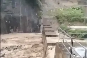
As one of the most landslide-prone areas, the Ca Mau Provincial People's Committee leadership revealed that in the past 13 years, over 350km of the province's coastline has eroded, resulting in the loss of more than 5,200 hectares of land—equivalent to the size of a commune.
The latest report from the Ca Mau Provincial People's Committee shows that the total length of the coastline currently undergoing erosion exceeds 105km. Of which, extremely dangerous erosion spans over 43km (11km on the West coast and over 32km on the East coast); while dangerous erosion extends over 62km (22km on the West coast and over 40km on the East coast).
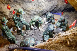
Representatives from the Ca Mau Irrigation Sub-department warn that with the current severe erosion rate unless immediate protective measures are taken, coastal erosion will continue to claim a significant amount of land and protective forests. These are areas of land and forest that have developed over centuries. If erosion continues to advance inland, it will not only result in further land and forest loss but also pose a risk to various built infrastructure, requiring emergency protection measures. The construction of protective structures in such cases would be very costly, and the restoration of lost land and forests would be extremely challenging.
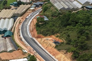
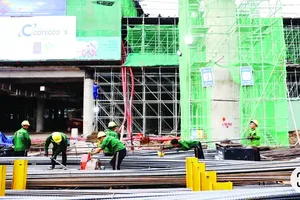
Mr. Le Van Su, Deputy Chairman of the People's Committee of Ca Mau Province, stated that Ca Mau has completed over 55km of sea dikes, with a total budget of VND1.72 trillion, and 9.2km of riverbank embankments, with an investment of VND391 billion. However, the situation of erosion continues to evolve in a complex manner. Currently, Ca Mau Province is constructing and implementing the project on prevention and control of coastal and riverbank erosion in the 2021-2025 period, with a vision to 2030 in the province.
The province will invest in building 177 works to prevent and control coastal and riverbank erosion, with a total investment of more than VND31 trillion. Specifically, during the period 2021-2025, 30 projects will be constructed with a budget of over VND6 trillion, and during the period 2026-2030, 147 projects will be built with a budget of over VND24 trillion.
The purpose of the project is to address landslide incidents that directly impact the safety of coastal residents, coastal infrastructure, and coastal protective forests. The project involves investing in the construction of a coastal dyke that also functions as a roadway, to prevent tidal surges, block waves, and prevent erosion.
Additionally, the project includes building anti-erosion structures combined with reforestation to restore mangrove and coastal protective forests, contributing to environmental protection, creating livelihoods for local residents, and utilizing carbon credit potentials. The project also involves constructing river training works in key areas, estuaries, and coastal regions.
Since 2016, the provinces and cities in the Mekong Delta region have experienced a total of 779 landslide sites extending 1,134 km. Of these, 666 sites along riverbanks account for 744 km, and 113 coastal sites account for 390 km. Among these, 281 sites covering 528 km are classified as extremely dangerous and require protective construction, 155 sites covering 306 km are considered dangerous, and 343 sites covering 300 km are classified as normal landslides.
Preliminary statistics from five localities (An Giang, Dong Thap, Can Tho, Vinh Long, and Ca Mau) over the past five years (2018-2022) indicate that landslides have caused the collapse and loss of at least 2,500 houses, resulting in damages of over VND304 billion, and have forced the relocation of over 20,000 households living in high-risk areas.