These applications are helping residents access information, handle administrative matters, and interact with local authorities more easily.
Convenience powered by digital data
On October 13, Tran Lam, a resident of Binh Tan Ward, drove his family into central Ho Chi Minh City for an outing, planning to visit Ben Thanh Market for sightseeing and shopping. Concerned about parking, he checked the VNeID app's “Integrated Transport Platform” feature.
Within minutes, he found a parking lot managed by the Youth Volunteer Force on Phan Chu Trinh Street, next to Ben Thanh Market. VNeID displayed the number of available spaces, parking fees ranging from VND25,000 (US$0.96) to VND35,000 (US$1.35), and the type of parking facility. The platform’s integrated navigation feature also made it easy for him to reach the lot.
In addition to locating car parks, the platform allows users to search for motorcycle parking facilities, bus stops, and routes, and book coach and air tickets.
“I find it very convenient because I can look up information and plan my itinerary directly on my phone. If parking reservations and online payments were added, most travel needs could be met with just a few taps,” Lam said.
According to the Administrative Police Division for Social Order of the Ho Chi Minh City Department of Public Security, the city is the first locality in Vietnam to complete the full integration and interconnection of public transport services by bus and urban railway on VNeID’s Integrated Transport Platform.
This marks progress in connecting different modes of transport within a single ecosystem, with the aim of providing residents with more convenient and transparent services. Data integration enables users to look up information and access services, with electronic identification and authentication being gradually incorporated to improve management efficiency and protect passengers’ rights.
Beyond transport-related conveniences, local authorities are expanding the use of data to serve residents in other areas, including urban management, information provision, and the resolution of everyday community issues.
Connecting neighborhoods to improve management efficiency
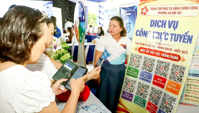
 "An Hoi Tay Ward police officers guide residents in using the VNeID app in Ho Chi Minh City.")
Le Thi Hong, a resident of Dien Hong Ward, was recently offered a plot of land in the ward with assurances that it was fully cleared for construction and could be built on without restrictions. Concerned about the land’s legal status and planning regulations, she opened the ward’s “Commune-level Spatial Management” app to check the information. Although still in the trial phase, the digital map clearly displayed specific details about the plot.
Alongside the “Commune-level Spatial Management” app, Dien Hong Ward is developing a “Neighborhood Management” app based on practical needs and feedback from its 26 neighborhoods.
According to Nguyen Hai Phong, head of the ward’s Division of Culture and Social Affairs, the app helps update residential data and identify people in need of healthcare or social welfare support. It also receives reports on public security and order and environmental sanitation issues and tracks their resolution. By centralizing data, the app helps local authorities improve management efficiency and monitor progress in handling issues in each neighborhood.
In Cau Kieu Ward, local authorities are developing the “Cau Kieu Ward Digital Twin” app, which integrates local data, information on 27 neighborhoods, and public service information, allowing residents to look up information and submit feedback to the authorities.
Vice Chairman of the Cau Kieu Ward People’s Committee, Phan Thai Hoang Son, said the app provides an additional channel for interaction between residents and local authorities, helping them receive and resolve issues arising in the area.
Other localities are also implementing digital solutions tailored to practical needs.
Tan My Ward uses a geographic information system (GIS) map to manage 181 water access points for firefighting and has introduced a food traceability model for school meals at all seven public schools in the ward.
Hung Long Commune has launched a “Digital Transformation Space” to help residents look up information and complete administrative procedures.
Xuan Thoi Son Commune has established public service support points to help residents digitize documents, submit applications, make online payments, and track the results of administrative processing.
Dong Thanh Commune has deployed an artificial intelligence-powered advisory robot and a 24/7 automated public administration station, providing additional channels for residents to access information and complete administrative procedures.
To mark Vietnam Digital Citizen Day on October 15, localities across Ho Chi Minh City are organizing activities to improve residents’ digital literacy and skills. An Hoi Tay Ward has launched initiatives to guide and assist residents in accessing and using online public services and digital applications and utilities, while also developing digital streets. Phu Nhuan Ward is focusing on helping residents use VNeID, submit applications online, access official information, make digital payments, and recognize online scams.
At the city level, the Ho Chi Minh City Digital Citizen Day 2026, combined with Lifelong Learning Week, was recently organized by the municipal People’s Committee, providing residents with opportunities to explore new learning methods enabled by digital technology.