A key element of this plan involves the utilization of the spaces along the Saigon and Dong Nai rivers, emphasizing their role as green-ecological areas to foster regional connectivity. However, in practice, several provinces and cities have implemented strategies for exploiting spaces along rivers, yet these efforts are predominantly concentrated within their respective administrative borders, not fully utilizing the potential of sustainable interconnectivity.
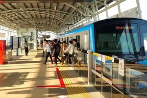
On December 23, the People's Committee of Thu Duc City inaugurated a riverside park along the Saigon River, drawing thousands of visitors for sightseeing and photographing. This highlights that the parks and riverside paths along the Saigon River are creating green spaces, partially fulfilling the needs of the city's residents.
Restrictions on amenities, public service spaces
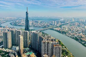
The Saigon River, stretching 256 km in total, flows approximately 80 km through the territory of HCMC. The city divides the Saigon River into two zones: the upper stream extending from Dau Tieng Lake to Phu Long Bridge (District 12) and the middle-lower stream from Phu Long Bridge to the Red Light Cape (the junction of Saigon River and Soai Rap River in District 7). As one of the tributaries of the Dong Nai River, the Saigon River holds considerable potential to contribute to the economic and social development, as well as the urban landscape of the Southeast region and HCMC. However, over the past time, the city has not fully capitalized on this natural advantage.
In particular, the areas on both sides of the Saigon River have not been installed with utility systems and public service spaces, and the riverside landscape is still underdeveloped. The planning for the Saigon River banks is disjointed and lacks coherence. Some high-potential areas along the river, such as the Thu Thiem New Urban Area, Thao Dien Residential Area (Thu Duc City), and Thanh Da Peninsula (Binh Thanh District), are yet to be fully realized.
According to the HCMC Department of Planning and Investment, there are plans for the revitalization and enhancement of the Saigon River corridor in the city center from now until 2025. These plans are closely tied to economic and service development initiatives. In the subsequent phase, spanning from 2025 to 2045, projects will be implemented to invest in green infrastructure integrated with tourism, economic activities, and entertainment services.
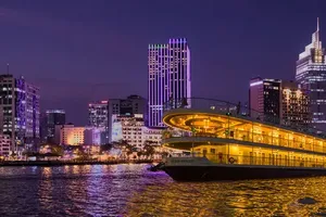
Concurrently, efforts will be made to refine the legal framework for planning in this riverside area. In practice, HCMC has actively invested in constructing various services along the Saigon River, exemplified by the recent opening of a park by the People's Committee of Thu Duc City. Previously, in mid-March 2022, the city completed and inaugurated the Bach Dang Park (District 1), covering an area of approximately 1.6 hectares.

Cultural, tourist hub
The planning and development of the Saigon River corridor have been receiving attention from the HCMC leadership. Dr.-Architect Nguyen Tuan Anh, Head of the General Planning Division under the Department of Planning and Architecture of HCMC, noted that the Saigon River corridor planning and management project is now largely complete. The overarching goal of this initiative is to foster community cohesion, enhance regional connectivity, and promote global outreach.
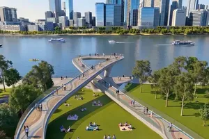
By 2030, the vision is to transform the Saigon River banks into a cultural destination in Asia, with an annual growth rate of 8-8.5 percent. The project envisions the central riverside area featuring parks, children's playgrounds, pedestrian walkways, meditation spots, and communal activity spaces, creating verdant urban retreats for residents. Additionally, the city's rich history and river culture will be highlighted through museums, artistic zones, historical landmarks, street food ventures, and various entertainment activities. In the Cu Chi area, the strategic advantage of the river will be harnessed for investments in ferry terminals, cargo transportation, and the advancement of waterway transport.
Furthermore, a comprehensive urban and landscape planning strategy has been outlined to transform the Saigon River into a green corridor and a connecting pathway with adjacent urban areas. It includes exploring urban development or redevelopment strategies that align with heritage sites along the Saigon River region, as well as developing high-end residential areas along the river to attract capital from social resources.
Over the past two decades, HCMC has allocated numerous hectares of land for urban development along the Saigon River corridor, with 930 hectares already having completed planning. The core challenge, at present, is the need for a specific investment plan and strategy to bring these urban development plans to fruition.
To actualize the planning and management initiative for the Saigon River corridor, architect Khuong Van Muoi, former HCMC Architects Association Chairman, emphasizes the importance of a clear delineation of responsibilities. The government is expected to take on specific roles, while the call is made for private sector involvement with transparent benefits. Regardless of the investor, strict adherence to the planning is crucial to maintaining the landscape on both riverbanks, serving the well-being of residents, and contributing to the city's sustainable development.


)