 |
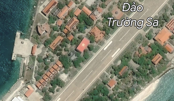
Vietnamese flag in Truong Sa Islands is shown in Google Map |
Through the Google Maps application, users can easily see the image of the national flag on Truong Sa Lon Island.
The move comes amid a complaint by Vietnam’s government about the missing flag design on the building’s roof in a recent image.
Previously, on July 10, Internet users did not see the image of the Vietnamese national flag on the roof of a hall on Truong Sa Lon Island, part of Vietnam’s Truong Sa (Spratly) Archipelago in the East Vietnam Sea when viewing Google Maps in satellite image mode. The top of a building on Truong Sa Lon Island, in Vietnam's Truong Sa Archipelago, is displayed in white. That location is where Vietnam's national flag has been displayed.
Following frustrations about Google's satellite map not showing the image of the Vietnamese national flag on Truong Sa Lon Island (Spratly Archipelago, Vietnam), on July 11, Head of the Ministry of Information and Communications’ Authority of Broadcasting and Electronic Information Le Quang Tu Do was working with Google upon the issue.
In its explanation to the Ministry of Information and Communications, a Google representative said that Google did not blur or change satellite images provided by third parties. According to Google, the image was not displayed due to poor image quality and Google said it was working to replace a satellite image on its mapping software which rendered the Vietnamese flag on the rooftop of a building in the Spratly Islands.
Mr. Le Quang Tu Do said that the Ministry of Information and Communications has asked Google to quickly fix this.
The large national flag on the top of the hall came into being from the idea of painter Nguyen Thu Thuy which could be seen from above by people on a plane or through satellites. After many months of preparation, the national flag with a size of 12.4m x 25m, or 310 square meters, and made up of 310,000 ceramic mosaic tiles of 3cm x 3cm, was completed in 2012.
Google on July 211 said it would fix the issue within a week, and up to now, on July 18, the image of the country's flag on Truong Sa Lon Island has been restored by Google Maps. It's been a week since this incident happened.

