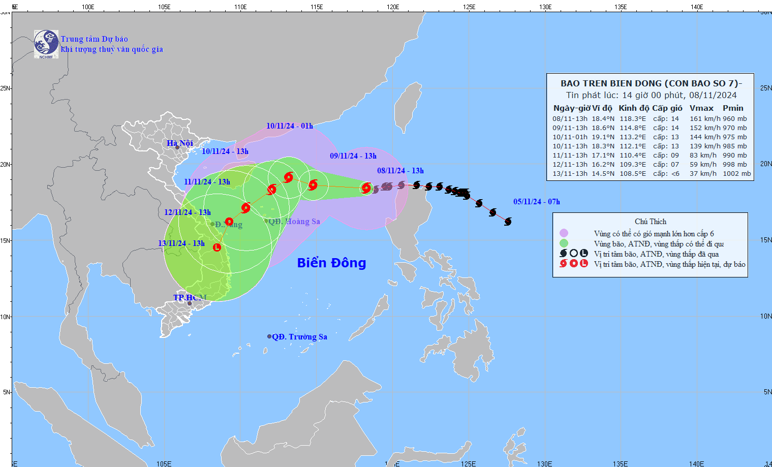
According to the National Center for Hydro-Meteorological Forecasting, at 1 p.m. on November 8, the typhoon's center was located at approximately 18.4 degrees North latitude and 118.3 degrees East longitude, over the Eastern part of the North East Sea. The strongest winds near the typhoon's center were level 14 (150-166 km/h), with gusts reaching level 17. The storm was moving Southwest at around 15 km/h.
It is forecast that by 1 p.m. on November 9, the typhoon will move Northwest at a speed of 15-20 km/h, at 18.6 degrees North - 114.8 degrees East, about 420 km Northeast of the Paracel Islands. The storm's intensity will be level 13-14, with gusts of level 17. The dangerous zone extends from latitudes 16.0 degrees North to 21.0 degrees North, and east of longitude 113.0 degrees East. The disaster risk level in the Northern part of the East Sea (including the Paracel Islands) is level 3, and level 4 to the East.
By 1 p.m. on November 10, the typhoon is expected to move Northwest, with a possible shift to the Southwest at around 10 km/h, gradually weakening. The typhoon will be located at 18.3 degrees North, 112.1 degrees East, about 200 km North of the Paracel Islands, with wind speeds of level 13 and gusts reaching level 16. The dangerous area will extend from latitudes 16.0 degrees North to 21.5 degrees North and longitudes 110.5 degrees East to 116.0 degrees East. The disaster risk level will be level 3, affecting the Northern part of the East Sea, including the Paracel Islands.
By 1 p.m. on November 11, the typhoon is forecast to move Southwest at 5-10 km/h and weaken further. It will be located at 17.1 degrees North, 110.4 degrees East, about 170 km Northwest of the Paracel Islands, with wind speeds of level 9 and gusts up to level 13. The dangerous area will stretch from latitudes 16.0 degrees North to 21.0 degrees North and longitudes 108.5 degrees East to 115.0 degrees East. The disaster risk level will remain at level 3, affecting the Western part of the Northern part of the East Sea, including the Paracel Islands.
From 72 to 120 hours onward, the typhoon will continue to move Southwest at 10-15 km/h, with further weakening expected.
In the Northern part of the East Sea, winds will range from level 8-11, with winds near the typhoon's center reaching levels 12-14, gusting up to level 17. Sea waves will be 4-6 meters high, and near the center, waves may reach 6-8 meters. The sea will be very rough. Ships operating in these dangerous areas are at risk of thunderstorms, whirlwinds, strong winds, and high waves.


