")
Since its completion, Ho Chi Minh Highway, cutting through the western parts of Hue City and Quang Tri Province, has been a catalyst for economic change, sparking growth in trade, tourism, and services. Yet, this progress is undercut by peril. Many sections of the vital artery have severely degraded and are riddled with accident risks, a threat that escalates dramatically with the frequent landslides of the storm season.
It’s not just the main highway. The feeder roads, often the sole access routes for remote communities, present their own dangers. National Highway No.49, winding from Hue City up to A Luoi, and National Highway No.15D to La Lay International Border Gate, have become notorious “black spots”. For many drivers, navigating these narrow routes with their hairpin turns and precipitous slopes is like running a gauntlet of hazards.
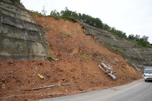
The 77.5-kilometer La Son – Tuy Loan Expressway, a two-lane route built with an VND11.5 trillion (US$438 million) investment, is another case in point. Since opening, it has become a hotspot for recurring landslides. In some spots, heavy rains send water gushing from mountain cracks and underground springs, dragging soil and rock down onto the asphalt.
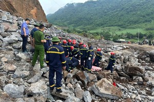
In a stark example from late November 2024, torrential rains triggered five separate slope failures, dumping an estimated 21,000 cubic meters of debris onto the road and causing extended gridlock at Khe Tre Intersection.
Da Nang City’s mountainous communes are a focal point for seasonal landslides. In late 2024, a single downpour in Tra Van Commune isolated nearly 5,000 residents, and an 18km road still shows the scars of over 10 landslides now. This recurring threat leaves residents like 75-year-old elder Tran Quoc Tran feeling scared and helpless when cut off.
In response, the local authorities are planning reinforced community shelters for evacuations and have surveyed sites for retaining walls. However, the crucial VND7-8 billion ($267,000) reinforcement project is currently stalled while awaiting funding from the city.
Helicopter pads and proactive measures
For chronically isolated communes like Phuoc Thanh and Phuoc Loc in Da Nang City, preparation is key. Phuoc Thanh Commune has implemented disaster response plans based on the “four-on-the-spot” principle of self-reliance. Meanwhile, Phuoc Loc Commune has established food reserves in key hamlets so they can wait out any isolation caused by floods or landslides, according to its chairman Do Hoai Xoan.
Looking beyond ground-level solutions, the region’s military command built a helicopter landing pad in Phuoc Thanh Commune in 2021. It serves as a strategic point to stockpile and airlift emergency supplies to stranded communities.
Da Nang Military Command is now expanding this initiative, building another landing pad in Tra Tap Commune and proposing another for Hung Son Commune. These pads will be crucial lifelines for delivering aid and supporting rescue missions when mountain roads become impassable.
In Gia Lai Province, key routes like National Highway No.1D face a severe rockfall risk. Precarious cliffs hang over the busy highway, threatening to collapse during heavy rains. Locals report this danger is worsened by new resort developments, where construction crews are excavating unstable slopes, further increasing the likelihood of a major and potentially tragic landslide.
In the western area of Quang Ngai Province, many roads have a high risk of landslides in the rainy and stormy season, such as Ho Chi Minh Highway, NH40B, Truong Son Dong Road, Provincial Road 672, Provincial Road 673, Provincial Road 675, Provincial Road 677, Mang Roi Pass avoidance road, Plei Krong Hydropower resettlement road, and the Ngoc Hoang - Mang But - Tu Mo Rong - Ngoc Linh road. Fearing for their safety, many people do not dare to take it and choose to travel on the old pass road.
“We have two highly vulnerable routes here: NH40B and the Mang Roi avoidance road”, said Party Secretary Vo Trung Manh of Tu Mo Rong Commune in Quang Ngai Province. He explained that following the recent Storm No. 3, they have assigned teams to constantly monitor conditions. “If a landslide happens, we’re ready to mobilize equipment and personnel to clear the road immediately so people’s travel isn’t disrupted.”
")
The situation is tense in other areas as well. On Prenn Pass in Lam Dong Province’s Da Lat City, authorities have cordoned off minor landslide spots. In Nghe An Province, National Highway 16 was hit by serious landslides on July 28, just a day after being temporarily cleared, trapping relief convoys and cutting off communities once again. The same day, officials in Quang Ngai’s Mang Ri Commune reported that key roads had collapsed, severely disrupting transport.
Earlier, in the early morning of July 27, in the communes of Song Ma, Sop Cop, Huoi Mot, and Chieng So in Son La Province, heavy rain occurred, causing flash floods and landslides that left at least 2 people dead and 4 missing.
These isolated incidents paint a larger picture of a nationwide crisis. The Vietnam Road Administration confirms that nearly 600 vulnerable landslide locations have been identified across the Northern and Central regions, a stark reminder of the immense challenge of keeping Vietnam’s roads safe during the turbulent rainy season.