Flood levels in Dong Thap Muoi and Long Xuyen Quadrangular areas of the Mekong Delta have risen gradually and are expected to stay above danger mark 3, till the end of October.
")
According to the National Hydro Meteorological Forecasting Center, flood levels will continue to surge gradually for the next one to two days in the above areas.
By October 13 the highest flood level will touch 4.8m at Tan Chau Station on Tien River and 4.25m at Chau Doc Station on Hau River. At the other main stations in Dong Thap Muoi and Long Xuyen Quadrangular areas, levels will touch the danger mark of level 3.
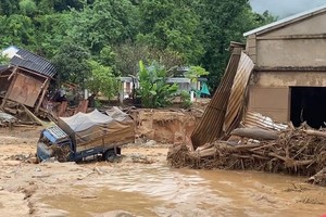
Ever since September 20, when flood levels began to rise rapidly, more landslides have occurred in An Giang Province, destroying 46 kilometers of road and displacing 567 households.
4,200 hectares of rice crops have been completely destroyed and 10,500 households are facing acute food shortage.
2,000 hectares of rice crops in Can Tho City are lying submerged under floodwaters and thousands more are under a similar threat. Six children in the city are reported drowned.
According to the Steering Committee for Flood and Storm Prevention in Dong Thap Province, rescue teams have saved 22 people from floodwaters.
Nearly 15,000 houses are submerged and damages worth VND328 billion (US$15 million) are estimated for the traffic infrastructure alone, in Dong Thap Province.
Long An Province has evacuated households from flooded areas expected to face more flooding in mid October. Evacuees will now return only after the floodwaters recede to continue their rice cultivation. Over 5,600 households are lying submerged under 0.4-0.5 meters of floodwaters.
In related news, flooding also occurred in rivers in the central and Central Highland regions because of the low pressure zone that triggered heavy rains over wide areas during the last few days, according to the national weather bureau.
Rivers in provinces from Ha Tinh to Binh Dinh and other Central Highland provinces are also heavily flooded.