Deputy Director Truong Xuan Ty of the Da Nang Department of Agriculture and Environment has signed an official document urging relevant agencies to proactively respond to the coming cold air, heavy rains, and flood warnings for local rivers.

According to the Central Region Hydrometeorological Station, from October 26 to 29, Da Nang is expected to experience widespread heavy to very heavy rain, with rainfall totals ranging from 150 to 350 mm, and localized areas exceeding 500 mm.
Rivers in the area may see rising water levels, with flood peaks on the Vu Gia – Thu Bon and Tam Ky rivers likely reaching second and third-stage warning levels, and in some locations above second-stage warning level. Low-lying and urban areas face a high risk of flooding, while flash floods and landslides are possible in mountainous zones.
By the night of October 26, a strengthening cold front will bring northeasterly winds at force 4–5, gusting to 6–7 along coastal areas. In response, the Da Nang Civil Defense Steering Committee has directed local departments, armed forces, and local governments to remain on high alert, closely monitor weather updates, and promptly inform residents. Measures are being implemented to prevent flooding, landslides, and ensure safety for people, vehicles, and infrastructure.
Local authorities have been instructed to identify high-risk zones, deploy monitoring teams, and prepare evacuation plans if necessary. The Department of Construction will inspect and address flooding and erosion sites on major roads, while the Department of Agriculture and Environment is tasked with ensuring the safety of agricultural operations.
The Department of Culture, Sports and Tourism, along with local authorities, has ordered outdoor tourism and recreation sites to safeguard both tourists and infrastructure. The City Military Command and Border Guard forces, together with coastal districts, must monitor marine weather conditions and advise vessels to avoid going to sea during dangerous weather. Reservoir management units have also been ordered to enhance monitoring and regulate water discharge to ensure downstream safety.
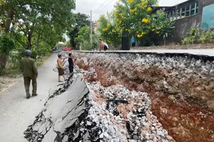
Heavy rains have already caused landslides and traffic disruption in mountainous areas of Da Nang. On National Highway 40B, near the Nam Tra My Waterfall, landslides have blocked parts of the road, while mud and rocks on the Tra Tap inter-commune road have temporarily cut off access. Several low-lying sections, including Tien Hiep intersection and roads leading to Tra Lien commune, are currently flooded.
Local authorities have advised residents to stay indoors unless necessary, and to check their surroundings for potential landslide risks. In the next 6 to 48 hours, rainfall in lowland and northwestern mountainous communes is forecast to reach 150–350 mm, with some exceeding 450 mm, while southern mountainous communes may see 200–500 mm. Soil moisture data indicates that several areas in Da Nang are near saturation (over 90 percent), heightening the risk of further landslides.

Meteorologists warn of flash floods in small rivers and streams, and land subsidence or slope failures in up to 59 communes and wards across Da Nang City in the next six hours. Rainfall totals during this period are expected to range from 30–80 mm, and in southwestern mountainous areas, up to 100 mm.
In a same news, a leader of Dak Pek Commune in Quang Ngai Province today said that the authorities are mobilizing vehicles to urgently level and clear rocks and soil at the landslide site on Lo Xo pass of Ho Chi Minh road (section through Dak No Village in Dak Pek Commune), to soon clear the road.
Due to prolonged heavy rain, rocks and soil from the positive slope suddenly slid down, burying the road surface with a volume of about 100m³. All vehicles passing through this area were forced to stop and could not move.
Lo Xo pass is an important traffic route connecting Quang Ngai Province with Da Nang City. Currently, the repair work is being urgently deployed to soon clear the road, ensuring safety for people and vehicles.