")
As of the afternoon of September 22, water levels in many rivers in Hanoi, including the Tich, Bui, Nhue, and Day rivers, have risen significantly. Flooding has affected several areas in the western, northern, and southwestern parts of Hanoi since September 9 and has yet to recede.
According to the Northern Midland and Mountainous Region Hydro-Meteorological Station and several meteorological experts, Hanoi and many other locations in Northern Vietnam have experienced continuous moderate to heavy rain over the past two days, accompanied by a decrease in temperature due to the influence of cold air from the north and the circulation of typhoon No.4 in the central region. Consequently, the water levels of the Tich and Bui rivers have risen again.
Measurements indicate that the water levels of the Bui and Tich rivers began to decrease from around September 16-21 but only receded slowly and remained above the level-3 warning. From midnight to the morning of September 22, heavy rain caused the water levels of the Bui River at the Yen Duyet Hydrometric Station (Chuong My District) and the Tich River at the Vinh Phuc Hydrometric Station (Quoc Oai District) to increase hourly.
 yesterday (Photo: SGGP)")
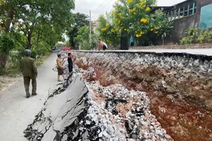
By the afternoon of September 22, Provincial Road No.412B from Can Hau Commune to Dong Yen Commune (both in Quoc Oai District) was still submerged in deep water. On the dikes, the local authorities continued to set up checkpoints and warning signs prohibiting heavy vehicles from accessing the dikes. In the villages along the Bui River in Nam Phuong Tien and Tan Tien communes (Chuong My District), many houses remained flooded.
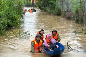
The Hanoi Steering Committee for Disaster Prevention – Search and Rescue reported that more than 13,000 people have yet to return to their homes due to the high water levels in the Tich, Bui, Day, and Ca Lo rivers.
")
Meteorological agencies have warned that Hanoi and several other locations in Northern Vietnam will continue to experience moderate to heavy rain until the evening of September 23. With the return of rain and rising river levels, areas along the Bui and Tich rivers, particularly in Chuong My, My Duc, and Quoc Oai districts, are likely to be flooded for the next 4-6 days.
On September 22, in response to the prolonged rain in the northwestern highlands, the Ministry of Agriculture and Rural Development issued three urgent dispatches, directing Hoa Binh Hydropower Co. to open three bottom outlets to regulate the amount of water flowing into the reservoir, ensuring the safety of downstream structures.
On the same day, the authorities in Muong Lat District of Thanh Hoa Province urgently evacuated 48 households in Muong Chanh Commune to safety. Prolonged heavy rain in the area, combined with floods from the neighboring country of Laos, caused the Sim Stream to rise, inundating many houses and cutting off Provincial Road 521E, which connects Muong Chanh Commune and the district center, posing a risk of landslides and flash floods. Heavy rains also caused landslides in many places along National Highways 15 and 16, cutting off communication between the lowlands and Muong Lat District.
")
In Nghe An Province, early in the morning of September 22, the local authorities and border guards promptly evacuated residents in Muong Piet Village of Thong Thu Commune in Que Phong District to safety before a landslide occurred.
In the same afternoon, Chairman Nguyen Hung Cuong of the People's Committee of Quang Tho Commune (Vu Quang District, Ha Tinh Province) reported that due to the impact of heavy rain, dozens of cubic meters of soil from Dong Vai Mountain had collapsed onto the house of Tran Dinh Cuong in Hamlet No.1. Fortunately, there were no casualties.
Moving to the South, on September 22, the water level on the Hau River in Can Tho City reached 2.08m, exceeding the level-3 warning by 0.08m. The rising water on the Hau River flowed into canals, flooding many streets along Ninh Kieu Wharf in Ninh Kieu District of Can Tho City.
Localities in the Mekong Delta are scrambling to address the situation of late summer-autumn rice and the early ripe winter-spring rice crops that have fallen over in the fields and are at risk of mold. Preliminary statistics show that nearly 15,000ha of rice in the provinces of Bac Lieu, Soc Trang, Hau Giang, and Can Tho City have fallen over due to prolonged rain over the past three weeks. Bac Lieu province was the most severely affected, with over 12,500ha suffering losses ranging from 10-70 percent, and over 200ha being completely destroyed.

In related news, on September 22, Tri An Hydropower Co. announced that it would release floodwaters through the spillway downstream, as the inflow from upstream reached an average of 2,000 m³/s, reaching an elevation of 60.5m (the dam's safety elevation is 62m).
At the Ta Lai Station (upstream of the Dong Nai River), the water level rose rapidly, currently at a level between warning level 2 (112.5 meters) and warning level 3 (113 meters), while at the Bien Hoa Station (downstream of the Dong Nai River), the peak tide level was high, close to warning level 2 (2 meters).
Tri An Hydropower Co. announced that it will reduce flood discharges for downstream areas at 10:00 a.m. today with two scenarios.
If the water level at the Bien Hoa Station is below 1.8 meters (warning level 1), Tri An Hydropower Co. will release water through the spillway at a flow rate of 150-300 m³/s, with a total discharge downstream of 1,000-1,150 m³/s.
If the water level at the Bien Hoa Station exceeds warning level 1, Tri An Hydropower Co. will release floodwaters through the spillway at a flow rate of 0-150 m³/s, with a total discharge downstream of 850-1,000 m³/s.
Low-lying areas along the La Nga River in Tan Phu and Dinh Quan districts (Dong Nai Province), Tanh Linh and Duc Linh districts (Binh Thuan Province) are at risk of flooding due to floods. In addition, many low-lying areas in the downstream of the Dong Nai River, such as Long Thanh, Nhon Trach, Vinh Cuu districts (Dong Nai Province) and Thu Duc City of HCMC are also at risk of flooding.
Tri An Hydropower Co., the largest hydropower plant in the South, contributes a significant amount of electricity to the national grid and also regulates water for production and consumption for millions of households, as well as participating in flood control for the downstream area and preventing saltwater intrusion.