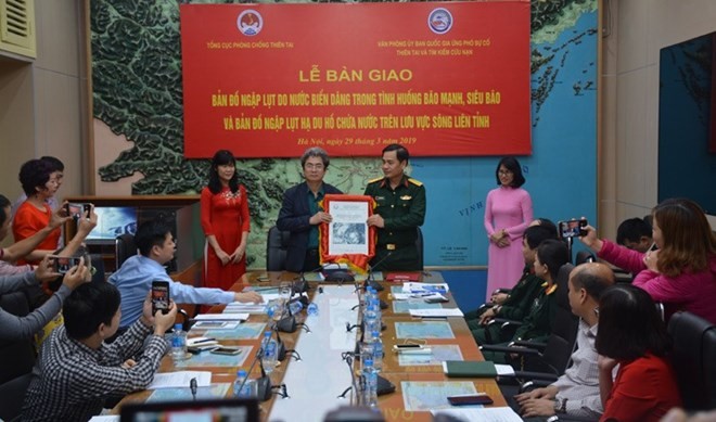
The Vietnam Disaster Management Authority (VDMA) under the Ministry of Agriculture and Rural Development, in coordination with the Office of the National Committee for Disaster Response, Search and Rescue, handed over copies of the two maps to relevant agencies in Hanoi on March 29.
At the handover ceremony, Vu Xuan Thanh, Deputy General Director of VDMA, said the first map was designed to cover five scenarios corresponding to the strength of storms hitting the country’s coastal areas.
The other map corresponded to reservoirs along inter-provincial river basins in the case of high discharges and dam failures of six rivers – Hong (Red), Ma, Thu Bon-Vu Gia, Ba, Srepok and Se San.
Thanh said the maps will help the central disaster prevention committee, city and province-level climate offices and central relevant agencies plan for climate change.
Colonel Nguyen Huu Hung, deputy head of the National Committee for Disaster Response, Search and Rescue Office, and also Deputy Director of the Ministry of Defense’s Rescue Department, said they will help the office coordinate and carry out of search and rescue operations.
At the event, experts from agencies, including the Vietnam Institute of Water Resources Research, Institute of Hydrometeorology and Climate Change and the University of Water Resources presented their work in researching, drafting and building the maps.
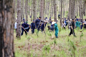
Facing the increased threat of natural disasters, the Prime Minister assigned the Central Steering Committee for Natural Disaster Prevention and Control to develop flood maps.
The maps will help the steering committees for natural disaster prevention and local authorities prepare for natural disasters.
The 24th conference of parties to the United Nations Framework Convention on Climate Change (COP 24) listed 10 countries most severely affected by climate change, of which Vietnam ranked 6th.
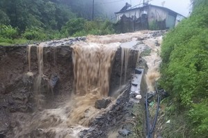
Natural disasters are a big threat to the nation’s sustainable development.
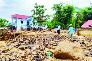
Over the past 20 years, the country has suffered most types of natural disasters (except tsunamis), causing heavy losses to human life, property, infrastructure and production.
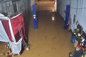
On average, about 400 people die or go missing each year due to natural disasters. Economic losses due to natural disasters impact about 1-1.5 percent of GDP per year, of which the most serious damage is from strong storms and flooding.
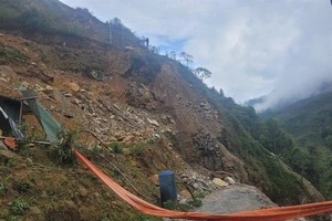
The Ministry of Natural Resources and Environment says coastal provinces are particularly at risk of strong storms and super typhoons. River basins are at high risk of flooding.
At the handover ceremony, Vu Xuan Thanh, Deputy General Director of VDMA, said the first map was designed to cover five scenarios corresponding to the strength of storms hitting the country’s coastal areas.
The other map corresponded to reservoirs along inter-provincial river basins in the case of high discharges and dam failures of six rivers – Hong (Red), Ma, Thu Bon-Vu Gia, Ba, Srepok and Se San.
Thanh said the maps will help the central disaster prevention committee, city and province-level climate offices and central relevant agencies plan for climate change.
Colonel Nguyen Huu Hung, deputy head of the National Committee for Disaster Response, Search and Rescue Office, and also Deputy Director of the Ministry of Defense’s Rescue Department, said they will help the office coordinate and carry out of search and rescue operations.
At the event, experts from agencies, including the Vietnam Institute of Water Resources Research, Institute of Hydrometeorology and Climate Change and the University of Water Resources presented their work in researching, drafting and building the maps.
Facing the increased threat of natural disasters, the Prime Minister assigned the Central Steering Committee for Natural Disaster Prevention and Control to develop flood maps.
The maps will help the steering committees for natural disaster prevention and local authorities prepare for natural disasters.
The 24th conference of parties to the United Nations Framework Convention on Climate Change (COP 24) listed 10 countries most severely affected by climate change, of which Vietnam ranked 6th.
Natural disasters are a big threat to the nation’s sustainable development.
Over the past 20 years, the country has suffered most types of natural disasters (except tsunamis), causing heavy losses to human life, property, infrastructure and production.
On average, about 400 people die or go missing each year due to natural disasters. Economic losses due to natural disasters impact about 1-1.5 percent of GDP per year, of which the most serious damage is from strong storms and flooding.
The Ministry of Natural Resources and Environment says coastal provinces are particularly at risk of strong storms and super typhoons. River basins are at high risk of flooding.