Within 24 hours, a total of 14 consecutive earthquakes were recorded in Quang Ngai Province, according to the Earthquake and Tsunami Warning Center under the Institute of Earth Sciences early this morning, October 6.
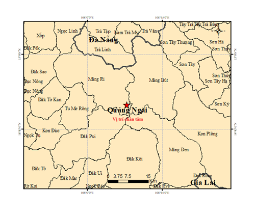
On October 5 alone, ten quakes occurred in the province, with magnitudes ranging from 2.6 to 4.3 on the Richter scale, concentrated around Mang But Commune (formerly part of Kon Plong District, Kon Tum Province, now within Quang Ngai).
By early morning on October 6, four additional quakes had been detected in Mang But and Mang Ri communes. The most notable was a magnitude 4.9 earthquake at 1:28:42 a.m. (Hanoi time) on October 6, centered at latitude 14.871 degrees North and longitude 108.13 degrees East, with a focal depth of about 8.1 kilometers. It was classified as a level-1 natural disaster risk — the strongest in the recent series.
Other minor tremors, ranging from 2.6 to 3.0 in magnitude, caused no damage but were clearly felt by residents in upland areas. Experts attributed the seismic activity to movements along the Tra My–Kon Tum fault zone, which has shown frequent activity in recent years.
The Earthquake and Tsunami Warning Center continues to monitor the situation and assess aftershocks throughout October 6 to provide timely alerts to local communities.


