The Department for Roads of Vietnam reported on the morning of October 10 that flooding continues to disrupt traffic along the Hanoi–Thai Nguyen Expressway, with several northern highways also inundated or hit by landslides and currently under urgent repair.

On the Thai Nguyen–Hanoi direction, flooding between Km28+800 and Km29+050 has reached a depth of 60 cm over a 150-meter stretch. In the opposite direction, from Hanoi to Thai Nguyen, water levels are about 15 cm deep over 100 meters.
Road management units are working closely with the Thai Nguyen traffic police to redirect vehicles at key junctions to prevent congestion.
Vehicles with fewer than nine seats traveling from Hanoi to Thai Nguyen or Cao Bang are advised to take the Hanoi–Thai Nguyen Expressway to the Bac Phu Interchange at Km26, exit to National Highway 3 at Km24, and then follow National Highway 37 toward Bac Ninh. In the opposite direction, from Cao Bang and Thai Nguyen to Hanoi, drivers should use Expressway CT07 to the Yen Binh Interchange at Km41+850, exit to National Highway 3 at Km42, and continue toward Hanoi and other lowland provinces.

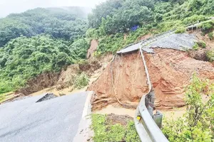
The Department for Roads of Vietnam also noted that several national highways under local management remain impassable due to deep flooding or large-scale landslides. These include sections of National Highways 3B and 279 in Thai Nguyen Province, and National Highways 34 and 34B in Cao Bang Province.
Particularly in Tuyen Quang Province, traffic remains blocked between Km63+710 and Km63+900 of National Highway 34 near Bac Me Hydropower Plant. Local authorities plan to cut into the hillside to open a temporary route before October 15.
The Department for Roads of Vietnam said it is continuing to direct road maintenance units to accelerate repairs and coordinate closely with local authorities to restore traffic at the remaining blocked points as soon as possible.

)