Just weeks into the rainy season, landslides, riverbank erosion and ground subsidence have emerged across several regions of the country, disrupting transportation networks, damaging homes and threatening the safety of thousands of residents. From the Central Highlands to the Mekong Delta, authorities are racing to implement emergency measures as geological hazards become increasingly severe.
Early-season rains trigger new landslides
Although the rainy season has only just begun, several major transportation routes have already been affected by landslides.
Along National Highway 28, which connects the North-South Expressway with National Highway 20 in Lam Dong Province, multiple landslides have occurred following a series of heavy rains. The most affected section is Gia Bac Pass, where dozens of landslide sites were recorded during the 2025 flood season.
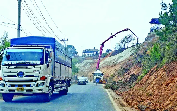
Despite a provincial emergency project worth VND70 billion (US$2.7 million) aimed at stabilizing the area, new landslides continue to appear. At Kilometer 51+900, a large volume of soil from an uphill slope spilled onto the roadway, creating dangerous conditions. Due to the risk of further collapse, authorities have prohibited traffic through the area since May 20.
Local officials have urged residents and transport operators to avoid the pass and use alternative routes.
In Quang Ngai Province, persistent heavy rainfall has caused landslides at multiple locations in Mang Ri Commune, damaging roads and threatening nearby residential areas.
Roads connecting Tan Ba and Mo Za villages have been partially blocked by soil and debris sliding from adjacent slopes. Authorities report that many of these sites had previously experienced landslides and remain vulnerable to further failures if heavy rain continues.
Meanwhile, in Dak Van 2 Village, a massive hillside crack stretching hundreds of meters has expanded significantly following recent storms. The crack threatens approximately 28 households and has raised concerns about a potential large-scale landslide.
Local authorities have restricted access to the affected area and proposed a detailed geological survey to determine long-term mitigation measures.
In the freshwater zones of Ca Mau Province, prolonged dry-season conditions left canal water levels exceptionally low. As the rainy season begins, rainwater infiltrates existing ground cracks, weakening soil structure and increasing the likelihood of subsidence and erosion.
Within less than a week, three subsidence incidents occurred along roads in Tran Van Thoi Commune, affecting nearly 100 meters of roadway. Several sections remain unstable and could collapse further if rainfall persists.
A separate incident in Khanh Hung Commune caused more than 35 meters of roadway to sink approximately 1.5 meters, severely disrupting local transportation.
Most recently, a riverbank collapse in Dat Moi Commune destroyed two homes after a 40-meter section of riverbank gave way, extending roughly 20 meters inland.
According to the Provincial Civil Defense Steering Office, Ca Mau has recorded 35 landslide incidents since the beginning of 2026. The disasters have damaged or destroyed 26 homes, causing estimated losses of VND5.5 billion (US$209,052).
Tay Ninh Province has also experienced major infrastructure damage. During the past week, two serious subsidence incidents caused hundreds of meters of road surface to crack, sink, and collapse, disrupting traffic and posing significant safety risks.
The latest event occurred on May 27, when approximately 40 meters of Kenh Ranh Road suddenly subsided by about half a meter. A day earlier, a 90-meter section of Thien Ho Duong Road collapsed into an adjacent canal, creating a deep undercut cavity and leaving surrounding pavement vulnerable to further failure.
Authorities have identified the northern bank of Duong Van Duong Canal as a critical hotspot, with 44 landslide locations currently requiring monitoring and intervention. Nineteen of these sites are considered severe and require urgent stabilization work.
Authorities accelerate emergency response
In response to worsening conditions, Tay Ninh authorities have declared an emergency situation in the Duong Van Duong Canal area to mobilize resources for disaster mitigation.
Provincial agencies have been instructed to closely monitor landslide developments, establish danger zones, and prepare evacuation plans where necessary. Funding from disaster prevention programs is also being allocated to support both emergency repairs and long-term solutions.
In Ca Mau, officials are implementing temporary stabilization measures using soil reinforcement, timber piles, geotextiles, stone mattresses, and soft embankment protection systems to maintain transportation access and reduce immediate risks.
Authorities are also commissioning geological surveys and soil analyses to identify appropriate engineering solutions for vulnerable locations.
In Lam Dong Province, efforts are underway to complete the upgrade of National Highway 28B. According to project managers, approximately 86 percent of the project has been completed, with remaining work focused on asphalt paving, drainage systems, roadside finishing and slope stabilization.
Construction teams continue to reinforce vulnerable embankments and maintain equipment on standby to respond quickly to any landslide incidents triggered by heavy rainfall.
The province has allocated nearly VND230 billion (US$8.7 million) for 16 emergency and repair projects addressing landslide damage to transportation infrastructure. However, several urgent projects remain behind schedule.
Provincial leaders have instructed agencies to accelerate implementation, particularly at high-risk areas such as Prenn Pass, Mimosa Pass and Sacom Pass, where unstable slopes could threaten major transportation corridors during the peak rainy season.
To improve resilience against natural disasters, Khanh Hoa authorities are updating risk maps and reinforcing preparedness strategies across vulnerable areas.
Officials are conducting comprehensive reviews of areas vulnerable to landslides, flash floods, subsidence, and infrastructure failures. Transportation networks, residential zones, and critical public facilities are being assessed to improve resilience and reduce future risks.
As climate change intensifies extreme weather patterns, experts warn that landslides, erosion and ground subsidence are likely to become increasingly common across the country, underscoring the urgent need for both immediate intervention and long-term adaptation strategies.