By yesterday afternoon a new storm had entered the East Sea at latitude 8.20 north and longitude 111.20 east, around the Truong Sa islands, reported the National Hydro-Meteorological Forecasting Center.
The storm is moving westwards at about 20 km an hour with winds of 39-49 kph and gusts of up to 62 kph, and is expected to lie west of the island.
Within the next 24 hours, the system is likely to move west and northwestwards at 15-20 kph and may gain in strength.
By 1pm Friday, the low pressure system is expected to be about 150 km east-southeast of the coast between the southern provinces of Ba Ria-Vung Tau and Ca Mau, packing winds of 50-61 kph and gusts of upto 87 kph.
According to meteorological experts, the low pressure system will move closer to Vietnam’s southern coast and then weaken.
Due to the low pressure, the southern areas of the East Sea, including the sea around Truong Sa, will face strong winds of upto 62 kph and gusts of upto 87 kph. Thunderstorms and rough sea will impact this area.
In addition, the low pressure combined with a cold front in the northern parts of the East Sea, will also cause rough seas and strong winds of 45 kph and gusts of 75 kph in the region between Binh Thuan and Ca Mau Provinces.
Meanwhile, rough seas and northeasterly winds of 39 kph and gusts of 62 kph will impact the mid areas of the East Sea.
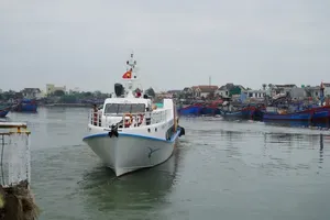
By yesterday evening, more than 25,000 boats with 160,900 people on board had been informed of the low pressure system, so that they could take safety measures in time, said the National Committee for Search and Rescue.