has been submerged under floodwaters.")
By midday and into the afternoon of August 21, heavy rains, flooding, and severe weather were no longer confined to Bac Ninh but had spread to Lang Son, Thai Nguyen, Tuyen Quang, and several other Northern provinces. The Ministry of Agriculture and Environment urgently called for swift measures in response to rising floods.
In an emergency dispatch sent to Northern mountainous provinces that afternoon, Deputy Minister of Agriculture and Environment Nguyen Hoang Hiep reported that rainfall across the region had ranged from 50 to 120 millimeters, with many areas receiving more than 250 millimeters. Some locations were at risk of extreme downpours exceeding 100 millimeters within three hours. Authorities warned of flash floods along small rivers and streams and landslides on steep slopes, particularly in Lai Chau and Dien Bien.
Early warning to local communities deemed essential
The ministry instructed local authorities to closely monitor forecasts and promptly communicate warnings to grassroots administrations and residents. Flood-prone villages and riverside communities must be inspected, while watch units are required to maintain round-the-clock presence at spillways and landslide-prone crossings. Localities were also urged to prepare personnel, equipment, and materials for rescue operations, ensure uninterrupted transport during heavy rains, and maintain strict duty shifts.
Widespread flooding reported
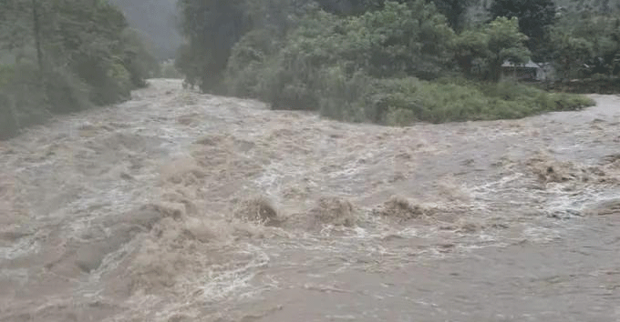
From early August 21, a strong convergence zone triggered torrential rains across the northeast, submerging large swathes of Lang Son, Bac Ninh, Thai Nguyen, and other provinces. Floodwaters rushed into markets, homes, warehouses, and livestock farms. Hydrological agencies warned that water levels on the Thai Binh River system would rise sharply between August 21 and 23.
 has been cut off by heavy rains.")
In Lang Son, persistent rain from the night of August 20 through midday August 21 caused flooding and landslides in several villages of Xuan Duong Commune. Local authorities evacuated residents and property from dangerous areas. In Huu Lien Commune, landslides blocked several roads, forcing four households to temporarily relocate. Provincial Road 243 was cordoned off for repair.

In northern Thai Nguyen, floodwaters swamped residential areas in Bac Kan and Duc Xuan wards, with roads inundated 30–50 centimeters deep and water flowing into homes and schools. Travel was severely disrupted along Doi Ky, Kon Tum, and the central square.

The Cau River rose rapidly, inundating riverside communities by more than one meter. Belongings inside homes were submerged, prompting residents to call for help on social media.


In northern Bac Ninh, several areas also experienced severe flooding. Landslides disrupted traffic on a number of roads. The hardest-hit areas included Son Dong, Dai Son, Yen Dinh, Tuan Dao, and Tay Yen Tu communes. Water levels reached nearly two meters in the deepest points, while many spillways were completely submerged, cutting off parts of Tay Yen Tu. Rainwater has flooded into homes, with levels at risk of rising further.

In Tuyen Quang, rainfall topped 100 millimeters in just a few hours in several communes. Hydrological authorities issued warnings of flash floods and landslides, ordering hydropower reservoirs to operate under emergency safety protocols.
In Quang Ninh, prolonged downpours combined with strong coastal winds battered mountainous communes such as Hai Son, Ky Thuong, Mong Duong, and the Mong Cai area, raising the risk of flash floods and landslides through the night of August 21.
The Department of Meteorology and Hydrology (under the Ministry of Agriculture and Environment) forecasted a flood surge on the Thai Binh River system from August 21 to 23, with water levels in the upstream rising by 2–8 meters, peaking at alert levels 2–3. Water levels on the Luc Nam, Thuong, and Cau rivers were climbing rapidly, with particularly dangerous conditions expected overnight on August 21 in areas prone to extreme rainfall exceeding 100 millimeters within three hours.