The city is accelerating efforts to digitize, enrich, and clean its land database, aiming to establish data that is “accurate, complete, clean, live, unified, and shared” to better facilitate administrative procedures.
Less paperwork, lower risks

Holding a copy of the land-use rights certificate for a property he was considering purchasing, Nguyen Thanh Hai, a resident of Tam Long Ward, Ho Chi Minh City, carefully checked key information, including the registered owner, land area, land-use purpose, mortgage status, changes involving the land parcel, and planning information. The process was time-consuming, as he mainly had to rely on paper documents and cross-check the information.
“Digitizing land data would make things much more convenient. When carrying out procedures, information about the property could be verified directly on the system, instead of people having to search for, photocopy, and bring along each document,” Hai said.
Hai’s expectation is shared by many residents when handling land-related procedures. Accurate, complete, clean, and up-to-date data would not only enable government agencies to improve land management but also help people save time and reduce paperwork costs, while limiting the need to submit additional documents repeatedly. For high-value transactions such as property purchases and sales, verified data would also serve as an important “safeguard” against potential risks.
According to Director of Gia Phat Real Estate and Construction Co., Ltd., Vo Van Thuong, complete, accurate, and regularly updated land data would help businesses shorten the time needed for legal due diligence before each transaction while providing a stronger basis for assessing potential risks. When information such as ownership, land area, and the legal status of a land parcel can be accurately cross-checked, buyers and sellers can have greater confidence when making transaction decisions.
According to the Ho Chi Minh City Department of Agriculture and Environment, the city is accelerating the digitization of its land database. More than 54,600 land-use rights certificates have so far been synchronized via VNeID.
Le Thi Xuan, a resident of Hoa Hung Ward, Ho Chi Minh City, recently received a notification on VNeID asking her to verify her land-use rights certificate. After checking and confirming that the information was accurate, she completed the verification.
“The information and a scanned copy of my land-use rights certificate are now displayed on my Level 2 VNeID account. I no longer need to carry the paper certificate when handling related procedures, which also reduces concerns about counterfeit documents,” Xuan said.
Connecting and integrating land data

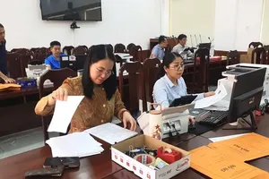
At the Ho Chi Minh City Land Registration Office, an average of around 4,000 land records are digitized each day. The records processed include first-time registration applications submitted by commune-level People's Committees and applications for changes to land information that are incomplete, as well as land parcels that already have information in the database but lack digitized records and therefore require additional scanning.
According to Head of the Office’s Cadastral Engineering and Archives Division, Nguyen Xuan Tien, the city is combining the digitization of supplementary records—including issued land-use rights certificates and legal documents—with cadastral map adjustments. It is also standardizing information and updating and verifying land-user information for parcels already included in the database but not yet meeting the criteria for Group 1 data—data that is already in use and meets the requirements of being “accurate, complete, clean, and up-to-date”—in line with guidance from the Department of Land Administration.
The most challenging task is processing certificates issued based on old documents. These records have to be cross-checked and converted to match the current cadastral map’s parcel and sheet references,” Nguyen Xuan Tien emphasized.
To facilitate transactions and administrative procedures, Ho Chi Minh City’s land database has now been electronically connected with the tax sector and several other agencies. Residents and businesses handling certain land-related procedures will gradually no longer need to visit public administrative service centers in person. Instead, they will be able to complete procedures through the public service portal, make online payments, and receive results as requested.
Once land data is fully digitized, electronic certificates replace paper-based certificates, and the relevant legal framework is put in place, land users will be able to exercise their rights more quickly and transparently.
The provision of fraudulent information and scams involving real estate transfers are expected to be gradually curbed. Land-related administrative procedures will also become simpler as they move fully online, allowing land users to submit requests for land procedures from anywhere, according to their needs.
According to the Ho Chi Minh City Department of Agriculture and Environment, more than 400,000 land parcels in the city still need to be digitized. The city is mobilizing resources to achieve a target of digitizing at least 95 percent of all land records by the end of 2026.
For compensation and site clearance for public investment projects, the land database enables authorities to identify which parcels have been issued land-use rights certificates, determine the area of each type of land, and retrieve digitally signed scans of certificates from the database for comparison with compensation plans.
This will help ensure accurate compensation, reduce the time required for verification, accelerate site clearance, and enhance the city’s urban governance capacity.






)