Inspectors have ordered that all road signs related to the Can Tho Bridge be reposted as the confusing signage has caused severe gridlock ever since the connection opened three days ago.
The My Thuan Project Management Unit, Vinh Long City Transport Department inspectors and Can Tho City Transport Department inspectors checked the road sign system at the bridge on April 27.
On April 26, thousands of people did not know which way to go after crossing the bridge because road signs pointing towards Can Tho, the Mekong Delta’s largest city, only read “Tra Noc Airport,” said a local resident.
The resident said that many intending to go to the city went in the opposite direction because they thought the road would just lead to the airport.
Phan Quang Du, director of the one-member limited liability company responsible for managing and operating the Can Tho Bridge, said the road sign system at the bridge was not yet completed.
He said that although the bridge had been completed, the sign system was handled by an independent contractor, not his company.
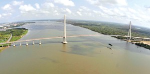
The Can Tho Bridge, the longest main span in Southeast Asia, opened to traffic on April 24 after nearly 6 years of construction.
The bridge spans the Hau River and aims to replace the ferry system to ease traffic congestion on National Highway 1A and help facilitate traffic flows between HCMC and the delta.
The bridge has four lanes for vehicles and two lanes for pedestrians. It links Binh Minh district of Vinh Long province to Cai Rang district in the city of Can Tho. It was built by domestic and foreign contractors, including Taisei, Kajima and Nippon Steel (TKN) of Japan.
The project has a total investment capital of US$342.6 million sourced from Japan’s official development assistance (ODA) and the Vietnamese State budget.
The bridge was originally scheduled for completion on December 14, 2008, but was delayed for nine months after a section of the bridge collapsed during construction in September 2007. The accident killed 54 people and injured 80.

