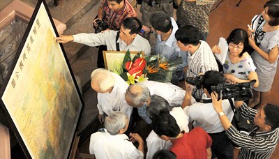
Crowds of people are rushing to the National Museum of History in Hanoi on learning of the existence of an ancient map dating back to the Qing Dynasty of China, showing all the geographical provinces of China and published in Shanghai in 1904, which clearly shows that the Paracel and Spratly Islands were never part of China.
The “Hoàng triều trực tỉnh địa dư toàn đồ” map showing all the provinces of China is undeniable evidence of Vietnam's sovereignty of the Hoang Sa (Paracel) and Truong Sa (Spratly) archipelagos.
Not only people from Hanoi but from other localities are also streaming into the National Museum of History to view the map.
The National Museum of History plans to exploit and display the map from July 27 so that more people can view this evidence of the territorial sovereignty of the country.
According to Nguyen Thi Tuyet, who has worked for many years in the public communication section of the museum, said the museum will take up the task to announce this map, as well as other sovereignty data, to the whole world.
On Saturday morning, Tran Son, a war veteran in Hoang Mai District in Hanoi was present at the museum. “This map will provide helpful evidence for Vietnam to resolve disputes with China over the ownership of the two islands in the East Sea. The map is not large but confirms that Paracel and Spratly are very much part of Vietnam and the truth cannot be refuted,” the old veteran said.
Sharing time with the old veteran, Hong Nhung a student at the University of National Economy said that as soon as information about the map was known, she went from Gia Lam by bus to the museum to view the ancient map in person.
Historian Duong Trung Quoc said that Vietnamese researchers used to have access to many different Chinese maps like “Hoàng triều dư địa toàn đồ” (1728-1729), “Hoàng triều nhất thống dư địa toàn đồ” (1894), and “Đại Thanh đế quốc toàn đồ” (1905). All of these maps indicate that China stretched as far south as Hainan Island.
“This information is important when establishing territorial sovereignty, especially in the case of a dispute”, he added.
China’s historical books also said the same thing. In the book “Đại Thanh nhất thống chí (1842)”, the author claimed that the south pole of China is Nhai Mountain, located in the south of Hainan Island.
The Chinese elite class, especially the intelligentsia, has recently expressed their opinion on China’s “false” claim to Truong Sa and Hoang Sa. However, their voice is weak compared to the Chinese government propaganda. This false ownership claim has also entered text books and other documents in China.
“There is a growing nationalism about protecting the territory of the seas and islands among Vietnamese people. The only thing we lack is a bandmaster who will systemize, co-ordinate and promote the data,” said Dr. Mai Hong, who bought the map in 1977.

The Han-Chinese map published by Shanghai Publishing House in 1904 was created nearly two decades ago, between the rule of Kangxi Emperor of China from 1661-1722 to Guangxu Emperor from 1875 to 1908, says Dr. Mai Ngoc Hong, former head of the Library of the Institute for the Study of Chinese and Demotic Scripts and Cultures.
According to Dr. Hong, a researcher on Han-Chinese and Demotic Scripts, the map’s accuracy in terms of longitude and latitude is nearly on par with modern maps.
“This map, measuring 115cm long and 140cm wide, was made by experts at the Observatory of the Qing Dynasty, so it can be considered official,” Hong says.
Sharing the same view points, many scientists and historians such as Dr. Phan Van Hoang, former secretary of the Ho Chi Minh City Science History Association, said Vietnam has a large amount of sovereignty data on the Hoang Sa (Paracel) and Truong Sa (Spratly) islands in the East Sea, but the information has yet to be systemized and announced in a proper way.
A map of China published in 1904 showing that the Paracel and Spratly Islands did not belong to China should be announced widely to the world, and not just to local people and researchers, and in particular to all Chinese, said Dr. Phan Van Hoang.
Also, many local researchers like Nguyen Dinh Dau, Pham Hong Quan, and Ho Bach Thao possess valuable maps and data on Vietnam’s sovereignty over Hoang Sa and Truong Sa.


