")
As part of this vision, the city is prioritising the construction of major roads, bridges, and metro lines connecting the urban center with Can Gio Commune (formerly known as Can Gio Outlying District).
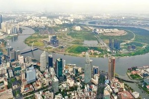
The municipal People’s Committee has recently submitted a proposal to the Prime Minister to adjust the city’s master planning towards 2040, with a vision extending to 2060.
Among the highlights is the southern coastal road, a key segment of a 940km coastal transport corridor running through nine southern provinces and cities.
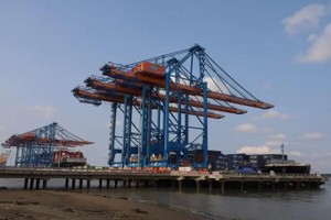
The section that crosses HCMC will start at National Highway No. 50, traverse the Soai Rap River, connect to the Can Gio International Transshipment Port and Phuoc An Port, and continue toward the Ben Luc–Long Thanh Expressway.
Once completed, this route is expected to serve as a crucial coastal economic artery, enabling more efficient use of port infrastructure, including Can Gio and Cai Mep–Thi Vai, and bolstering inter-regional connectivity.
Pham Viet Thuan, director of the Institute for Natural Resources and Environmental Economics in HCMC, said the coastal road would be a key driver for both local and regional socio-economic and tourism development.
When implementing this coastal section, it is crucial to thoroughly survey the terrain and geological conditions, as the area is complex, with many swamps, rivers, and canals.
“At the same time, it is essential to carefully assess feasibility and identify appropriate investment methods, given the substantial costs involved.”
Despite its strategic potential, Can Gio remains relatively isolated due to its reliance on Binh Khanh Ferry, a long-standing transport bottleneck.
Do Van Hen, 67, a resident in Can Gio, said, "although it’s just a river separating us, we still have to take the ferry, and each crossing takes about 30 minutes, sometimes even an hour, to get to Nha Be.
“It is very inconvenient. For generations, we residents of Can Gio have longed for a bridge over the river,” he said.
Although he has witnessed tremendous changes in the locality over the years, the long-awaited Can Gio Bridge remains a major concern for residents.
After years of preparation, the city is now moving forward with plans to invest in the bridge, offering renewed hope for seamless connectivity between Can Gio and the city center.
The city’s Department of Construction acting director Tran Quang Lam said once completed, the Can Gio Bridge would replace the Binh Khanh Ferry, cutting travel time between the city center and Can Gio to just 30 to 45 minutes.
The project is scheduled to be implemented during the 2025-28 period.
")
Metro connection proposed
In parallel with road and bridge projects, a proposal to develop a metro line linking the city center with Can Gio is also gaining traction.
VinGroup has submitted a request to the municipal People’s Committee, the city’s Department of Construction, and other relevant authorities seeking permission to conduct geological surveys for the project.
Earlier, in May, the city approved the group’s proposal to study and prepare a project under the public-private partnership (PPP) model.
The proposed line, approximately 48.7km in length, would begin at Nguyen Van Linh Street, follow the Nguyen Luong Bang - Rung Sac corridor, and terminate near the Can Gio coastal urban area on a 39ha site.
According to the investor’s timeline, project preparation would begin in 2025, with construction taking place from 2026 to 2028, and trial operations are expected by the end of 2028.
Vo Kim Cuong, former deputy director of the city’s Department of Planning and Architecture, said the metro line would significantly support the development of eco-tourism and coastal urbanisation in the city’s southern area.
“It will help ease road traffic congestion, improve transport infrastructure, enhance connectivity, and raise the quality of life for residents,” he said.
According to urban planning experts, the integration of HCMC with neighbouring Binh Duong Province - known for its industrial development and logistics, and Ba Ria- Vung Tau Province - home to deep-sea ports and coastal tourism, would offer a strategic pathway for expansion toward the sea.
This regional linkage could establish a seamless chain of industrial parks, urban centres, ports, and services, similar to urban development models in Shanghai, Singapore, and Bangkok.