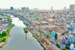
The Saigon River, which intertwines with the history, culture, and urban life of Ho Chi Minh City, is poised to become a strategic axis for urban economic development.
Beyond being a natural resource, the river is increasingly viewed as a "dynamic spatial axis" that can help develop a new growth model, forming a modern, sustainable riverside city.
Great potential for riverside economic development
")
Stretching 256 km through localities of Tay Ninh, Binh Duong, and Ho Chi Minh City before flowing into the East Sea, the river boasts substantial natural advantages for transportation, tourism, and green urban development.
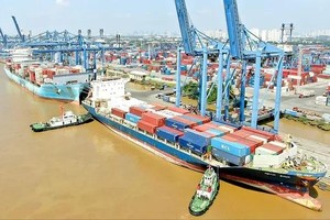
Since the 19th century, the river has been home to bustling trade ports, serving as the gateway for 75 percent of Indochina's exports, connecting Saigon-Gia Dinh to the world. Ports like Cat Lai and Tan Thuan used to be bustling with vessels and trade and commercial activities.
However, for many years, the riverside corridor has been developed in a fragmented manner, with rapid urbanization and population growth creating pressure that has led to pollution, reduced water flow, and disrupted landscapes. The lack of a comprehensive master plan has caused the potential of the Saigon River to "lie dormant" in the heart of the city.
In recent years, with a renewed approach to urban governance and a strong political will from the HCMC government, the potential and advantages of the 80-km section of the river in the city have begun to be tapped through various aspects, including planning, riverside infrastructure, cultural events, and waterway transportation.
The city has initiated programs and plans to improve water quality, relocate houses along canals, and construct riverside roads and embankments. Under the city's master plan for the 2021-2030 period, with a vision to 2050, a riverside road with a length of about 78 km and 4-8 lanes connecting Cu Chi to Can Gio will be built. The nearly 4 km stretch from Ba Son Bridge to Saigon Bridge is projected for completion between 2025 and 2030.
The river bus service is already operational, meeting the travel needs and allowing tourists and residents to enjoy the scenic views along the riverbanks. River festivals combining tourism with culture and sports have created a unique appeal, attracting hundreds of thousands of visitors and generating unprecedented tourism revenue, shaping new economic identities.
According to architect and scientist Ngo Viet Nam Son, cities with rich cultural legacies such as Paris, Washington, D.C., and Shanghai are often closely tied to their rivers, and they place a high priority on riverside planning and development.
Development axis, new growth driver
HCMC is currently orienting itself towards developing a riverside urban area, making the Saigon River a landscape-economic-ecological axis, connecting the city center with Thu Duc City, District 7, Nha Be and Cu Chi districts, and the Southeast region.
Son suggested that to fully realize the potential of the river, it is essential to devise urban planning along both riverbanks and develop transportation linked to the river.
The city needs to create green spaces and interconnected public areas where residents can move and explore along the riverbanks.
Developing multi-modal transport infrastructure that integrates waterway and land transport, including terminals, ports, and parking areas, will facilitate mobility for residents. This will help tap into tourism potential and stimulate economic growth.
Currently, dynamic development areas have emerged along the Saigon River, including Thu Thiem, Vinhomes Central Park, Thanh Da Peninsula, and Binh Quoi-Truong Tho. However, overall, the two riverbanks lack strategic connectivity and cohesive planning regarding architecture, transportation, tourism infrastructure, economy, and culture.
Le Hoang Chau, President of the Ho Chi Minh City Real Estate Association, said that effectively utilizing the Saigon River involves more than just developing riverside real estate; it requires focusing on sustainable green economic axes.
Night economy, waterway tourism, inland water transportation, modern logistics terminals, and cultural-ecological parks along the river are ecosystems that can provide a significant boost to urban economic growth.
Special emphasis is needed to develop the Thu Thiem and Binh Quoi-Thanh Da areas, transforming them into attractive spaces for investment and tourism, contributing greatly to economic growth. Furthermore, the Saigon River, extending from Binh Duong province, under the upcoming provincial merger plan, will open up a continuous development space along the river.
Thus, careful planning and land use management must be undertaken to enhance connectivity, tourism development, and economic growth for residents. Planning and management efforts should also consider connecting the growth poles of Binh Duong and HCMC along the Saigon River, creating a sustainable riverside metropolitan area.